
We had finished up our time in Kailua-Kona on the western side of the Big Island of Hawaii and were now heading over to the eastern side of the island. The main attraction in this area was Hawaii Volcanoes National Park which surrounds the highly active Kilauea as it continues to erupt on a constant basis. We would spend a full day exploring the national park and the nearby town appropriately named "Volcano", including a return visit in the early morning hours to see the orange glow of the volcanic crater before the sun rose. This page will also cover some of the attractions that we visited during our drive around the southern end of Hawaii, including stops at a coffee farm, an animal sanctuary, some dramatic seaside cliffs, and a black sand beach.


I'll reprise the map from the previous page to give an indication of where these places were located during our drive around the Big Island. We started out with a visit to Hala Tree Coffee Farm which was located just outside of the town of Captain Cook. They offered a free tour of their coffee-making process which we had reserved in advance for this quiet Tuesday morning. The coffee farm was located in the volcanic hills that sloped down to the waters far below and we were treated to some impressive views of the island as we parked our car. There were several cute dogs that came to say hello as we checked in at the front desk and surveyed the different types of cofee that the farm had for sale. There was one other recently married couple who would be taking the tour with us and that would be it for the group.


Hala Tree specialized in the production of Kona coffee, one of the rarest and most expensive types of coffee bean grown only on the Big Island of Hawaii. Kona coffee is a bit like champagne in the wine-making world, complete with lots of less expensive imitators trying to claim the famous name for themselves. Our tour guide walked us past some of the coffee trees growing their beans along the volcanic hill, with the specific soil and weather conditions here on the slopes of Hualalai and Mauna Loa giving Kona coffee its distinct nature. I'm not a coffee drinker and I won't pretend to know that much about coffee production which made this tour a useful learning experience. The coffee trees bloom in the early spring and then start putting forth green berries around April. Those berries ripen over the course of the summer months until turning bright red around the month of August when they can start being picked from the trees. Hala Tree emphasized that they used purely hand-labor for their picking process, no machines, which is part of the reason why their coffee was so expensive to purchase (roughly $50 for a one pound bag, about 4-5 times the normal price!)


The walking part of the tour didn't last very long before our small group was brought to this comfortable veranda spot. Here our guide talked a bit more about the coffee production process and how the different beans are used to make different flavors of the coffee available for sale. We were also able to do a tasting of several of the various coffee flavors which unfortunately I can't describe since I'm not a coffee drinker. Liz really liked one or two of them despite not caring for Kona coffee that much overall. It was highly relaxing to sit here with a cool breeze flowing off the hillside, enjoying a drink while watching the scenery out the big window below. We would definitely recommend Hala Tree with this being a case of high prices matching a high quality product.


Next up was the lengthy drive around the bottom edge of Hawaii which we knew would take several hours to complete. We were in no particular hurry to get to a particular destination and therefore were happy to stop whenever something that looked interesting popped up along the side of the road. We found this area towards the southern edge of the island near the town of Ocean View where a massive lava flow had passed through at some point in the past. According to the signs posted at this scenic viewing spot, it was the Lava Flow of 1887 that had run down from Mauna Loa and destroyed everything in its path. Despite well over a century of intervening time, the lava flow region still remained a black patch of volcanic rock where there was no soil for plants to grow. It made for a dramatic visual spectacle when driving along the road, one minute passing through dense tropical forests and the next minute encountering a place that looked like the surface of the Moon.


As we continued along the only main road in this part of the island, we saw some signs for a turnoff advertising a state park at the southern tip of Hawaii and a local farm which was selling honey and fresh produce. Since we were in no rush, we decided to make the detour and check out what there was to find in this area. First up was the advertised farm which was officially named Paradise Meadows Orchard and Bee Farm. The farm had a general store of sorts at the entrance which featured locally-grown honey and different kinds of nuts. Visitors were also encouraged to walk around the farm's grounds where they could encounter different animals; the star of the farm was a pig named Penny which we unfortunately didn't encounter during our brief stop. We did spot a local type of duck known as a Muscovy Duck and several brightly-colored parrots being held in cages. I recall that we purchased a couple small bags of nuts to use as snacks for the rest of our drive and they were quite good.

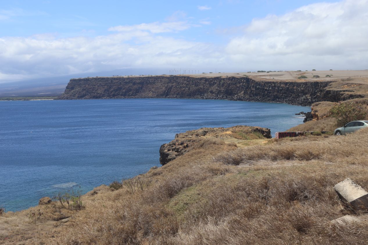


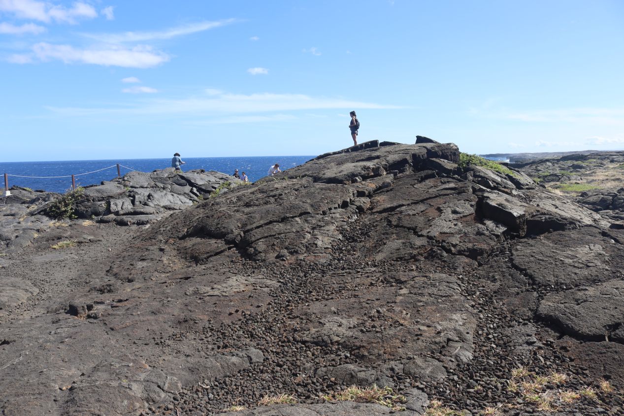
It was a drive of another 15-20 minutes continuing onwards from Paradise Meadows Orchard before we began to approach the southern tip of the island. The terrain here was nothing like what I would have imagined for Hawaii, a dry semi-arid climate with long brown grasses where horses and cattle were being grazed. It looked more like the Great Plains than an island in the Pacific Ocean! The road eventually reached its conclusion in a small parking lot located next to these dramatic cliffs. Here the same volcanic rock that we'd been seeing everywhere plunged down into the crystal blue waters of the ocean below. Despite its somewhat remote location there was a small crowd of visitors gathered here to enjoy the sights:


And not just enjoy the sights, as it turned out that some of them were preparing to leap off the cliffs into the water. Apparently this is a popular spot for cliff diving even though it's somewhat dangerous and people have died here when they didn't take the proper precautions. There was a little wooden platform that extended out over the cliffs which these brave / foolhardy individuals use to leap into the ocean below. We stopped for a few minutes because it looked like some of the college-aged visitors were about to jump, only to have them decide to exercise better discretion and back off from the edge. Probably the correct decision! I will say that the combination of the volcanic rock and the dazzling blue waters made for a spectacular view and I would have loved to try scuba diving here. This spot is about 500 feet away from the southernmost point in the entire United States which sits at 18.91 degrees north latitude for the curious. (I had previously been to the southernmost point in the continental USA at Key West which is approximately 24.54 north latitude.)


The one downside to driving down to the southern tip of the island was the need to retrace our path and return via the same route back to the main road once again. By the time that we'd done that it was past noon and we were ready to stop for lunch. The next little village along the main road was named Naalehu and had this place, Punalu'u Bake Shop, as its featured attraction. The bakery specializes in the sweet Hawaiian type of bread and it's been a popular rest stop for decades as visitors cross from one side of the island to the other. We found that Punalu'u was quite crowded with other tourists but there weren't too many other options available this far away from major cities so we ended up eating lunch here anyway. Once we continued onwards we were officially on the eastern side of the island, with these pictures taken a few miles ahead at a place named Haleokane Lookout. This side of the island was noticeably greener that the areas we'd been passing through which was a pattern that would continue for the next few days.


The bakery where we ate lunch turned out to have taken its name from this nearby seaside attraction, Punalu'u Beach. This is one of Hawaii's most famous beaches due to the presence of volcanic black sand made of basalt and created by lava flowing into the ocean. I had heard of black sand beaches before without ever seeing anything like them in person; sure enough, the sand really was made up of dark black pebbles that crunched underfoot. Larger rocks of the same volcanic basalt also littered the waterfront, and when combined together with cold fresh water flowing into the ocean and the rough waves pounding the beach, it turned out that Punalu'u wasn't a very good beach for swimming. We had thought about getting our beach stuff and decided that we were content to walk along the shoreline without putting on bathing suits.

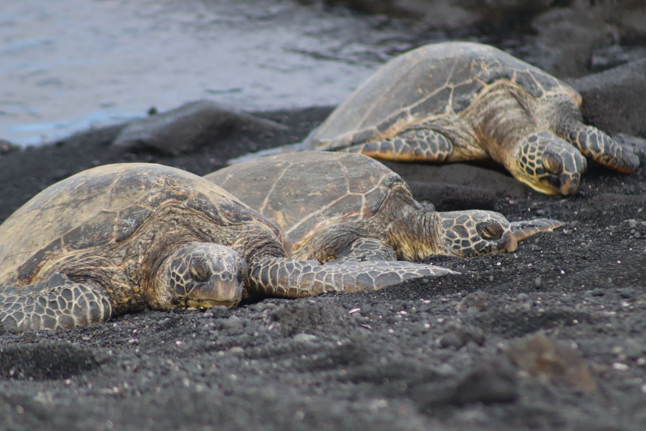


Punalu'u Beach is also known for being a frequent place to encounter sea turtles. Sure enough, luck was with us and there were a trio of green turtles relaxing along the edge of the beach in a protected area specifically built for their use. The green turtles or honu in Hawaiian are a threatened species that like to feed on the red seaweed that grows amongst the rocks at Punalu'u Beach. The presence of tourists doesn't seem to bother them any more than it had when we spotted sea turtles back on the North Shore of Oahu at Laniakea Beach. Most of the tourists were gathered around the sea turtles to snap pictures of them (as we were also doing), with only a few hardy souls braving the ocean itself. Generally speaking, all of the main beaches on the Big Island are located on the western side in the Kailua-Kona region, with the eastern side of the island having rougher surf conditions which don't lend themselves to swimming.

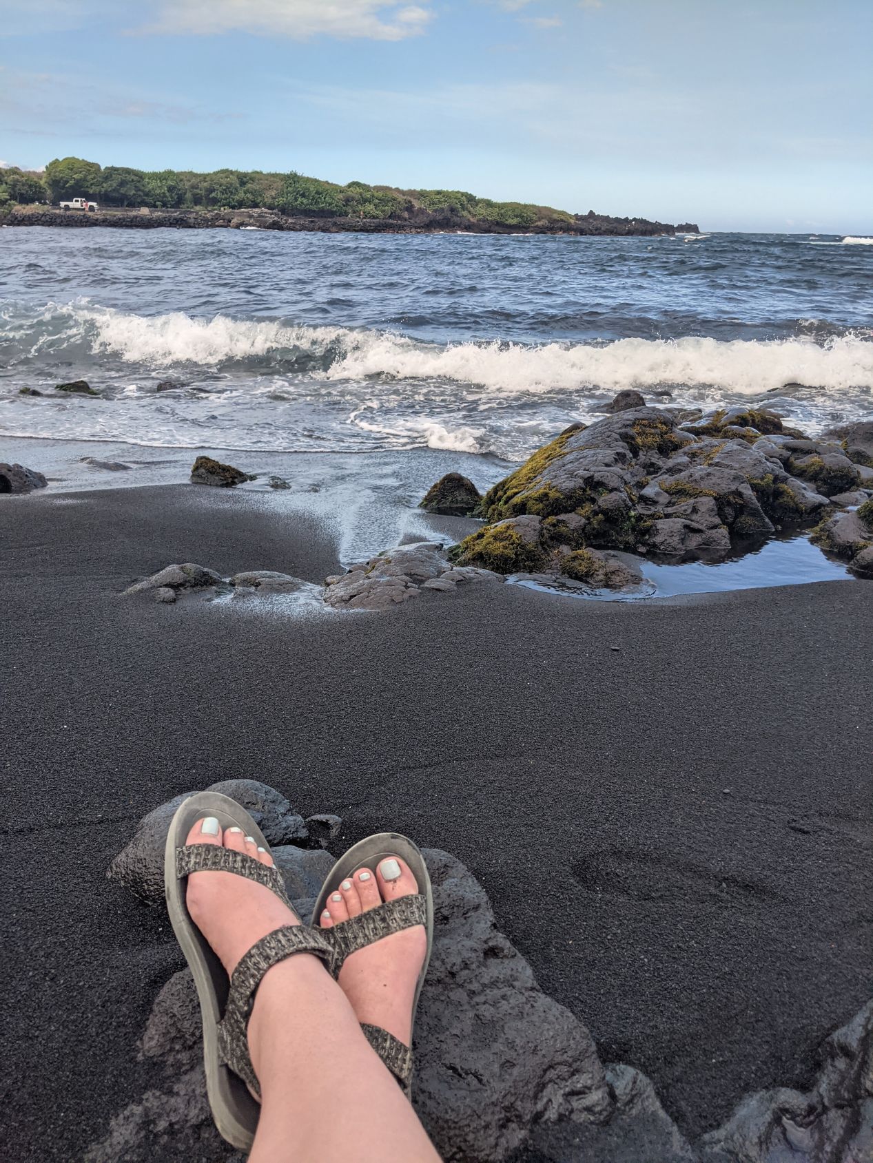


And here are a few pictures of the two of us enjoying the turtles and the black sand at Punalu'u Beach. We stayed here for about an hour to relax a bit and enjoy the scenery before continuing onwards with our drive. The conditions really were a bit too rough to stay longer and go into the ocean for a swim. Afterwards we made our way to Hilo, the only city on the eastern side of the island, where we checked into our hotel and spent the night. We returned back this way the next morning though as we arrived at Hawaii Volcanoes National Park in earnest after having driven past it the previous day:


We started out by stopping at the main visitor center which was already beginning to fill up with cars from arriving tourists. Kilauea Visitor Center had the standard National Park Service look, a sturdy wooden building packed full of maps and other information about the unique nature of the park. We looked at a small exhibit detailing the diversity of wildlife within the park's boundaries as well as purchasing a few souvenirs from the gift shop. There was a large painting here featuring the Hawaiian goddess Pele who has long been associated with the volcano of Kilauea. This painting was a replacement for an earlier version that dated back to 1929 and had been the subject of some controversy since it depicted Pele as a goddess with white rather than Polynesian features. The visitor center also helpfully contained daily updates on the condition of the volcanoes; Kilauea continued to erupt within its main crater but there was no active lava flow at the time of our visit. It was steadily releasing volcanic gases though and as a result Liz wore a mask anytime we were near the crater since they can be dangerous to pregnant women.

This was the helpful map provided by the National Park Service; click above for an enlarged version of the image. The total area encompassed by the park is enormous and covers a good portion of the eastern half of the island. However, most of the attractions and park infrastructure are clustered around Kilauea's crater (captured in the inset map at the top-right corner of the image) and therefore we would be spending most of our time in this region. Later on we would make the longer drive down the Chain of Craters road to the ocean as outlined in yellow on the map. There are a bunch of wilderness hiking trails that run for dozens of miles that few people visit and we wouldn't have time to explore on this trip.


We began our sightseeing in the park by driving west on the Crater Rim Trail towards some of the scenic overlooks. Our first stop was at the place named Wahinekapu or Steaming Bluffs where we had an excellent view looking down into Kilauea's caldera. We were a little over a mile away from the center of the crater and it was easy to see the smoke rising from the ongoing eruption off in the distance. For that matter, we could smell the sulfuric nature of the gases being released when the wind blew from the south. The dried lava inside the volcano's crater looked like a particularly barren patch of rock as unsurprisingly nothing could grow under those conditions. I wished that we were higher up somehow as it wasn't possible to see down to the bottom of the caldera from this vantage point.


There was a short hiking trail that led off from the same parking lot to something named Ha'akulamanu or the Sulfur Banks in English. This was an area where a good deal of volcanic gas was being released from underground so Liz stayed behind while I took 15 minutes to check out where the path led. It turned out that there were multiple places where steam was venting directly out of the ground, much like the steam that rises from a kettle when the water inside boils. That steam was warm to the touch when I ran a hand through the cloud of vapor and it had the trademark sulfuric stench similar to rotting eggs - not the most pleasant odor. It only took about five minutes of walking to reach the sulfur banks, a stretch of yellow-colored rocks that gave off more steam from underground and stunk pretty fiercely. I had seen similar geological conditions at Yellowstone National Park a decade earlier and for the same reason: volcanoes producing immense heat underground.


We continued following the Crater Rim Drive for a short while longer before hitting the literal end of the road at the Kilauea Overlook and Uekahuna. These were additional scenic overlooks which are as close as the public can get to the actual Kilauea caldera at barely more than half a mile's distance. I was most fascinated here by the informational plaque captured above that described how the landscape had dramatically transformed during the 2018 eruption of the volcano. Kilauea had gone through a period of low activity for the previous two decades only to pour forth an enormous quantity of lava out of its eastern rift zone. The net result was that the crater itself sank an incredible 1600 feet / 500 meters between April and July of 2018.  It would have been unbelievable if the sign didn't have "before" and "after" pictures showcasing the remaking of the landscape. This resulted in the Jaggar Museum having to be permanently closed as the ground underneath it ceased to be safe; it went from being nearly a kilometer away from the crater's edge to suddenly being right on top of it! This was a good reminder that both Kilauea and Mauna Loa are very much active volcanoes which can be unpredictable in nature.


Since we had reached the end of the road, next we turned around and drove back towards the visitor center area. Sitting near the visitor center was this building named the Volcano Art Center Gallery, an attraction that we condidered skipping but ended up being glad that we stopped to see. A converted former hotel that dated back to the early days of the park, this center served as a showcase for many local artists who created artwork associated with volcanoes or the national park in some fashion. There were paintings and sculptures here along with some excellent photography of the volcanic eruptions and flowing lava. (We were asked not to take pictures of the photographs but all of the other artwork was OK to capture.) We ended up spending about half an hour inside just checking out everything that was on display and later I would purchase an owl print of one of the local artists to give to Liz as a Christmas gift. The stuff in here was very impressive if also quite expensive to purchase.


We continued a bit further along the Crater Rim Drive, this time heading past the visitor center and into new territory for us. The next main attraction in line was Nahuku or the Thurston Lava Tube, a spot that's known for having strictly limited parking available for the tourists who arrive. We had been planning to drop off Liz and then for me to park the car elsewhere only to get lucky and snatch a spot from a departing tourist - ha! Nahuku was located only a short distance off Crater Rim Drive but the path to enter it took us through thick jungle foliage. This contrast was common throughout Hawaii Volcanoes National Park: bleak landscapes of volcanic rock where the lava had flowed sitting right next to lush green forests where it hadn't. It only took a few minutes of walking to arrive at the dark entrance to the lava tunnel itself:


Lava tunnels are formed when lava flows at a fast speed and carves out a channel for itself, then the surfaces hardens and crusts over followed by the lava draining out of the tube to leave it empty. We had visited a lava tunnel in the Galapagos a year earlier in 2021; that one had been hundreds of thousands of years old while Nahuku wasn't even a full century old. In fact, it had to be closed from 2018-2020 because it wasn't safe for the public to go inside while Kilauea was erupting in the vicinity. The inside of the lava tube appeared as though some giant monster had tunneled through the rock and Nahuku was significantly bigger than the other lava tubes we had previously visited. Without the electric lights installed by the park service, it would have been completely dark inside. The whole walk through the lava tube and back again only took about half an hour and was well worth the trouble of finding one of the scant parking spaces.


This was a good stopping point to get lunch and thus we backtracked outside of the park to the little nearby town of Volcano. Yes, that's the actual name of the town which pretty much exists to provide the services that can't be found inside Hawaii Volcanoes National Park itself, hotels and restaurants and the like. We picked the delightfully-named Lava Rock Cafe for lunch which featured burgers and sandwiches, nothing fancy but a nice meal for a busy day of sightseeing. There were a number of little boutique stores in Volcano as well and we stopped to look around in one named Kilauea Kreations which focused on quilting supplies. I know that Liz liked the ones with turtle or owl designs that depicted some of the local Hawaiian wildlife.

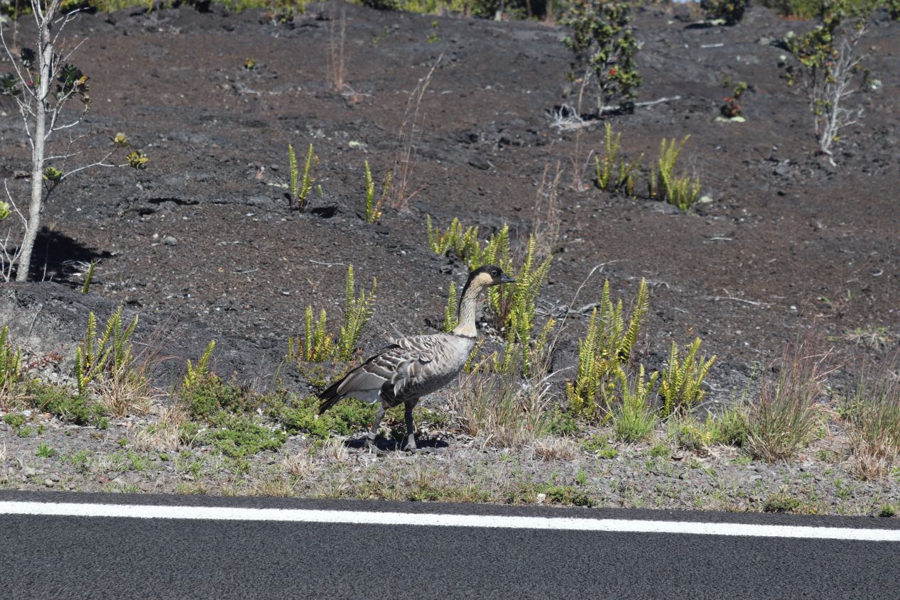


Speaking of wildlife, we had a great stroke of fortune almost immediately upon reentering the park. We were heading to the southern end of the park on the Chain of Craters Road when Liz spotted this bird along the side of the road. It was a Nene or Hawaiian goose, an animal endemic to the islands which serves as the state bird for Hawaii. Nenes are a threatened species with fewer than 4000 of them remaining in the wild, making them the world's rarest type of goose. They nearly became extinct before a successful breeding population helped rebound their population; that 4000 number might be low but it's up from an estimated nadir of only 800 Nenes around the year 2000. This is a beloved animal in Hawaii for its beautiful plumage and distinct call which sounds like "nene" and gave the bird its name. We were really lucky to spot one literally minutes after passing by the "Nene Next 5 Miles" road sign - the warning proved to be prophetic!


As we continued along the Chain of Craters road, we passed into this lava field left over from the 1969 eruption of Kilauea. Even though it had been decades since the lava stopped flowing, we could still chart the patterns of how the volcanic rock had molded itself over the landscape before cooling. It was also a bit disconcerting how the road wound its way through this dead patch of terrain immediately after passing through the thick forests that preceded the lava flow. I was reminded of the same volcanic landscape that we had seen in the Galapagos when we had hiked through a similarly recent lava flow on Isabela Island. A few tiny plants were just starting to grow back in sheltered locations while the vast bulk of the terrain remained too barren for any greenery.


Here are a few more pictures from the same 1969 lava flow. There was a small rest stop with a picnic area that had been placed along the side of the road, something that looked weirdly out of place against the background of all of that dried lava. It was very windy at this stop as we were getting close to a series of cliffs that fell away down to the shoreline below. I think that my favorite picture from this group is the last one posted above, the tiny snaking line of the road cutting through the otherwise devastated landscape where the lava had once flowed.


The Chain of Craters Road soon began to wind down those cliffs which provided a dramatic spectacle when combined together with the past lava flows. The distinction between lava and non-lava portions of the terrain was about as stark as possible, with the lava flows looking something like an oil spill that left its inky black fingers wherever they had passed. It was even possible to see the places where an initial lava flow had later been covered by a second, more recent flow of volcanic rock atop it. The native Hawaiian name for this ridge is Holei Pali and there were some ancient petroglyphs in the region where the Hawaiians had carved symbols into the rocks during the precolonial period. They would have been worth seeing if we'd had more time available, however the hike over to them was close to a mile in either direction and there were other parts of the park that took higher priority for us.


Eventually we reached the ending point of the Chain of Craters Road which concluded with a small parking lot next to something called Holei Sea Arch. This was a natural rock formation along the coastline where wind and water had combined together to erode an arch stretching approximately 90 feet / 25 meters in height. The eastern coastline was a wild thing here, no beaches to be found and instead consisting of cliffs that plunged down into the raging surf below. This is where the flowing lava from the volcanoes reaches its end point, eventually falling into the ocean and exploding with great force. The island of Hawaii is slowly growing in size over time as a result of this ongoing volcanic activity. (All of the Hawaiian islands are also slowly eroding away over time but the volcanoes on the Big Island are adding land significantly faster than it erodes away.)


Originally the Chain of Craters Road continued onwards here, running along the coast until reaching the edge of the park at another entrance outside the town of Kalapana. However, repeated lava flows from Kilauea in 1990, 2010, and 2018 wiped out the road which has since been closed off to the public. It remains an emergency service path today and I walked the short distance over from the Holei Sea Arch to take a closer look. The park service only went to the trouble of reestablishing a gravel road, most likely because it wouldn't be worthwhile to put down asphalt which would only get crushed under more flowing lava. The volcanic rock was thick here and it looked like it had required real effort to create even the rough gravel road in this inhospitable spot. These repeated eruptions had been particularly bad for the town of Kalapana, which used to have hotels and other tourist infrastructure right outside an entrance to the national park only to find itself suddenly cut off when the road was wiped out. What can you say though, the volcano is going to do its thing and anything in the lava's path simply gets wiped out.


We retraced our steps from the end of Chain of Craters Road and headed back to our hotel in Hilo, not making it back until evening was falling. That wasn't the end of our visit to Hawaii Volcanoes National Park, however. Liz needed to spend some time the next day working on a grant submission for her work (not what she wanted to be doing on vacation) and that gave me the opportunity to do a bit of sightseeing on my own. I wanted to return to the park in the early hours of the morning to try viewing Kilauea's caldera under cover of darkness. The national park is open 24 hours each day and our entry pass was good for the next few days which made it easy for me to return. I woke up around 3:30 AM and made the half hour drive back to the park with no other cars on the road, heading first back to the scenic overlooks where we had gone initially the previous day. Kilauea's crater was casting a fiery orange glow that I did my best to capture with the camera, sadly unable to get anything better than the above images despite my best efforts. I tried a bunch of different settings and I couldn't get anything in focus. Here's an image pulled from the Internet showing what this looked like if I'd been able to get a better picture.


After trying unsuccessfully to get a good picture of the crater from the scenic overlooks on the northern side of Kilauea, I realized that I might have better luck if I tried the opposite view from the southern side. I hurried along the Crater Rim Drive, trying to get over there while it was still dark so that I could watch the sun come up over the mouth of the volcano. I made my way to the Old Crater Rim Drive that ran for about a mile's length before reaching Keanakako'i Overlook, the best viewing spot from the southern end of the crater. This had once been a normal road only to be converted into a walking path once eruptions made it unsafe to drive; I could see ample evidence of why cars weren't allowed anymore as the road was cracked apart in several place. It took about 15 minutes of walking for me to approach the overlook at roughly 5:30 AM on the clock. There was a small crowd gathered here despite the early hour to take in views of Kilauea's caldera; I was looking north in these images so the rising sun was off to the right side of the central crater.
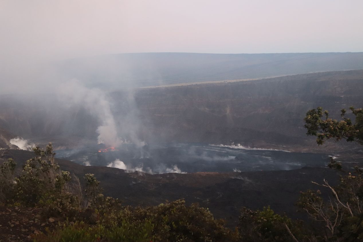


Keanakako'i Overlook was further away from the center of the volcano as compared with the scenic overlooks on the northern side, however it proved to have the better viewing experience thanks to an unobstructed line of sight down into the volcano's glowing mouth. Kilauea's eruption was very much still ongoing and when zooming in it was possible to see the lava in the center of the caldera bubbling and swirling around. It's hard to tell from these images but the fires down there were absolutely not static, instead they moved around brightening and darkening a bit like the light from a twinkling star. More visible was the smoke pouring out of the caldera everywhere that I looked, in traces all around the edges and in great billowing clouds near the center. Those volcanic gases are dangerous to breathe which is why visitors aren't allowed to get any closer to the volcano than this. There was a park guide doing observations of Kilauea while also telling stories about the traditional Hawaiian legends associated with the volcano, and as a result I stuck around for almost 30 minutes watching the sun rise over the crater's eastern edge while listening to these stories. It was a nice way to spend an early morning.


It was still early in the day and there was plenty of time remaining for me to explore other parts of Hawaii Volcanoes National Park. I had thought about what to do and decided that I'd try to hike across the Kiluaeau Iki crater, specifically targeting this hike for the morning hours before the sun rose completely and turned the crater's surface into an oven. This was a side portion of the main crater which had formed during the 1959 eruption when the lava pooling here hardened into a lake. There was a looping trail that started from the parking lot overlooking the crater and ran across its center before returning back to the same starting point. With no one else around to spoil the natural views, I drove over to the starting point and began the hike downwards to the crater's floor. As elsewhere in the park, the non-lava terrain was covered in dense vegetation that kept me shaded as I walked along the path. It took about 20 minutes to reach the bottom where the path continued out onto the volcanic rocks themselves and the greenery was left behind.


I felt a bit weird stepping out onto the former lava pool as the trail led me onwards into this flat section. This had been a vast pool of liquid magma a number of decades in the past only to cool over time and slowly begin to transform back into part of the forest once again. There were small, hardy bushes growing in between some of the cracks in the rocks even though the bulk of the terrain remained barren for the moment. I also noticed steam emerging from several openings in the ground, an indication that the active volcano wasn't much more than a mile off to the west. I was also walking westward which meant that the sun was rising at my back, and due to a coincidence it happened to be just popping above the rim of the crater wall at this moment. Thus I emerged from darkness into light over the course of a mere 5-10 minutes as I walked across this part of Kiluaeau Iki, giving me two different perspectives of what it looked like in daytime and night.


The sun had fully cleared the rim of the crater by the time that I reached the western edge and I was already beginning to sweat under its tropical heat. The sun was bright enough that pictures taken looking back in the eastern direction that I had come were little more than hazy lens flares. This side of the crater was noticeably rockier than the western side, with more cracks and tumbled boulders as opposed to the smoother initial entry area. It was hard to follow the hiking path here and it took me some time to find where it picked back up again over at the crater wall. I continued to be glad that I was doing this hike early in the morning as I suspected all of this dark volcanic rock would be scorchingly hot in the middle of the day.


Once I had completely crossed the Kiluaeau Iki crater, I was able to find the rest of the hiking trail and begin the ascent back up to the crater rim. It wasn't too bad of a climb and soon I was back amongst the trees once again making my way along the crater's edge en route to where I had parked. There were a few more views to take in from this higher vantage point, first looking off into the distance where I could see the main Kilauea caldera still belching forth its smoke into the clear morning sky. The land dipped downwards off in that direction and it really did look like the mouth of some monstrous beast. Spread out immediately below me was the Kiluaeau Iki crater that I had just crossed, with these pictures providing the best overview of its full extent. I think that this is about as close as one can get to hiking across the top of a volcano, at least as far as avoiding suicidally dangerous risks.
The conclusion of that hike also brought an end to our time spent in Hawaii Volcanoes National Park. While we were able to hit the major highlights, there's a vast wilderness full of hiking trails that we didn't even begin to explore. I had thought about doing the more strenuous hike up to the top of Mauna Loa before realizing that stumbling around in the dark at high altitude with no one else around and zero cell phone coverage probably wasn't the best idea. Maybe next time if we're lucky enough to return one day. The next page covers the final days of our Hawaii trip spent in the city of Hilo and along the north coast of the Big Island. We had a wonderful time on this vacation but it was starting to draw to a close.


