
St. John's is the only major city located on the island of Newfoundland, and it was the terminal destination for my trip through eastern Canada. With a population of about 110,000 people at time of writing. St. John's is known for its colorful houses and a long maritime tradition based around fishing and shipping. The surrounding Avalon peninsula contains about half of the island's population, with much of the rest of Newfoundland either sparsely populated or completely uninhabited. I was interested in visiting St. John's to see this isolated urban environment situated at the edge of the North American continent, hundreds and hundreds of miles away from anything of comparable size. Halifax is the closest city and it's more then 900 kilometers (550 miles) away across the waters of the north Atlantic, further than that if trying to take the ferry route. My trip would finally come to a close as I pushed to the utmost ends of the North American continent itself.


I arrived in St. John's in the evening as night was falling, roughly around 8:00 PM on the clock. This was later than I had expected since I had been delayed by a terrible thunderstorm that slowed down my drive from the tip of the Bonavista peninsula further to the west in Newfoundland. This precluded me from doing too much sightseeing in the city on this evening, but I did have time to visit Signal Hill before heading off to my hostel. Signal Hill is a natural promontory that overlooks the entrance to St. John's harbor. The city benefits from one of the world's best naturally sheltered harbors, with a pair of hills creating a thin entryway known as the "Narrows" into a protected deep water environment. The city of St. John's grew up around the western side of that natural harbor, and Signal Hill has been a critically important strategic location ever since the city was first settled. There was a battle fought on this spot in 1762 at the tail end of the Seven Years War, with the British storming a French encampment on the top of the hill and forcing their surrender. The British later fortified the position on top of the hill and kept a garrison here against potential attack, either from the French or the Americans.
Even though darkness was falling on my visit, I was still able to capture some wonderful panoramic shots of the city of St. John's spread out below me. This is a lopsided city from a design standpoint, with almost all of the buildings located on the western side of the natural harbor and nothing on the eastern side. It's also a hilly city, with the streets rising up from the waters of the harbor, although that was a bit hard to see here at the onset of night. I was also able to spot the Narrows from this vantage point, the shipping channel that led from the harbor out into the ocean proper. It was obvious why Signal Hill was so strategically important; anyone who held the heights would be able to stop ships from passing into and out of the harbor. There was one cargo ship heading out to sea at the time of my visit, likely getting ready to cross the Atlantic to a destination somewhere in Europe. This is the last land for the next 1500 or so miles before reaching Iceland, Ireland, or Portugal.


Signal Hill is probably most famous today not for its military value, but for its role in trans-Atlantic communications. The building pictured above, known as Cabot Tower in commemoration of explorer John Cabot, was constructed in 1897 for the 400th anniversary of the explorer's arrival in North America. It was built for use as a wireless station, and in 1901 the first transatlantic wireless transmission was received here by Guglielmo Marconi. St. John's location perched at the easternmost edge of Newfoundland made it a natural place over the years for various milestones involving the running of cables and radio signals across the Atlantic. I would have liked to take the tour of Cabot Tower, but it was already closed for the night when I arrived. The surrounding park area had a healthy number of walking and biking trails, and I was able to explore them for a little while before it became too dark. The last picture above captures one of the cargo ships heading out to sea, with nothing but open waters ahead for a very long time.

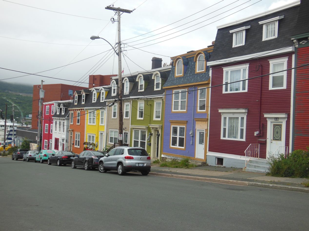

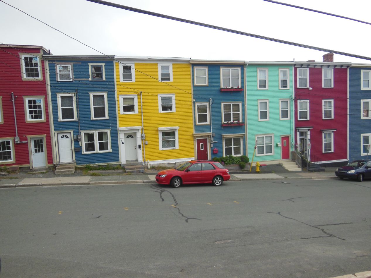
I was up early the next morning in the hopes of walking around some of the city while there was light to see but no crowds out and about yet. Before getting into anything else, I have to start with a few pictures of the distinctive houses from St. John's. The city is known for its colorful row houses, built up and down the hills that make up the downtown part of the city. I saw them everywhere and they were always painted in bright colors, sometimes to the point of being garish. I suspect that this rainbow of colors is employed in St. John's to offset the overcast and gloomy weather that the city endures for most of the year. If it's not raining in St. John's right now, give it time, it likely will be soon. I saw a number of little model houses painted like these row houses being sold as souvenirs, and it's one of my few regrets from this trip that I didn't stop to purchase one of them. That would have been $10 well spent.

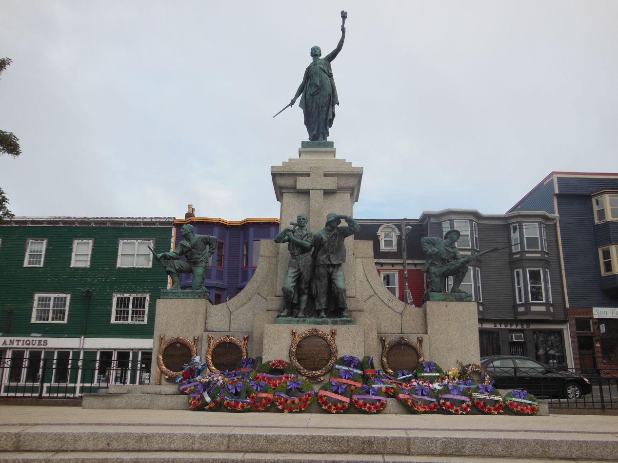


I started out by heading down to the harbor, where I visited a small green space known as Harborside Park. There was a monument here to the Royal Newfoundland Regiment and to the veterans of overseas Canadian wars, with a dozen fresh wreaths placed at the foot of the monument. They looked like they had been recently added, perhaps for the Canada Day celebrations about ten days earlier. The park was completely empty at the moment, likely because this was about 7:00 AM on a Saturday morning, and I was able to stroll around the waterfront and capture some more pictures of the harbor. In one of the pictures above, you can just see Cabot Tower on the top of Signal Hill off in the distance. There were also two life-sized statues of the dog breeds associated with this province, the Newfoundland and the Labrador. I understand that these are highly popular with visitors, and I made sure to take a few pictures for myself. Newfies and labs are both wonderful breeds of dog.

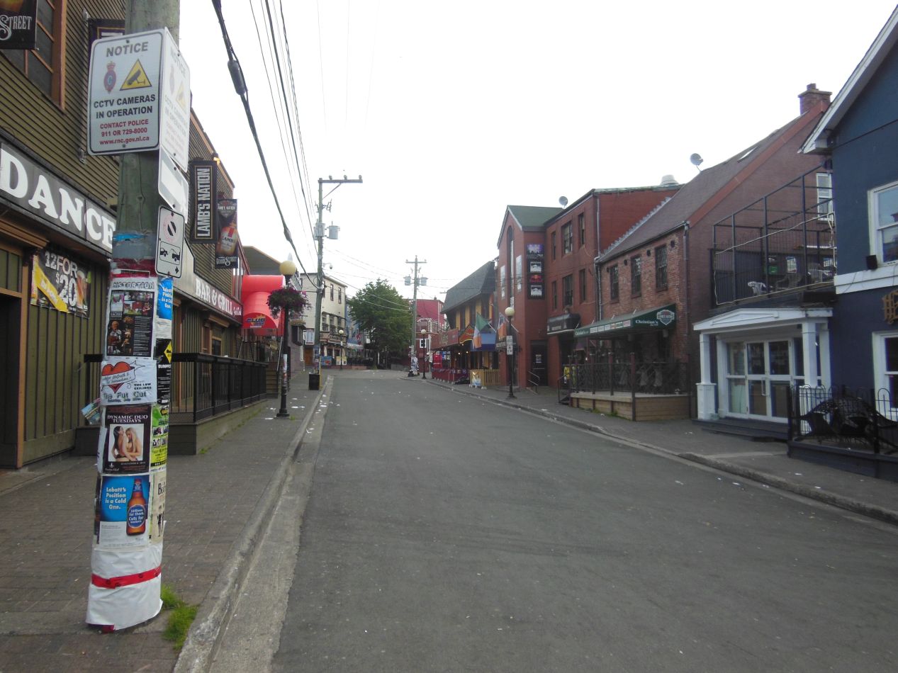


These next few pictures are some of the sights that I came across while walking the streets of St. John's. The Yellow Belly Brewery was one of the more interesting spots, located in what looked like an old stone building at the corner of an intersection. I walked through what seemed to be the bar district, with a lot of advertisements for clubs and live music on the windows. A short distance away was the St. John's City Hall, found in an unappealing concrete slab of a building. And there was the Mile One Centre, the sporting arena home to a series of minor league hockey teams based in the city. When I visited in 2013, the arena played host to the St. John's Ice Caps, an affiliate of the Winnipeg Jets and then the Montreal Canadiens. However, this team left in 2017 and at the time of writing there was no team based in the Mile One Centre. Unfortunately the remoteness of St. John's makes it difficult to host a professional team in the city.

This food truck was parked across the street from City Hall... I have no further comments. 

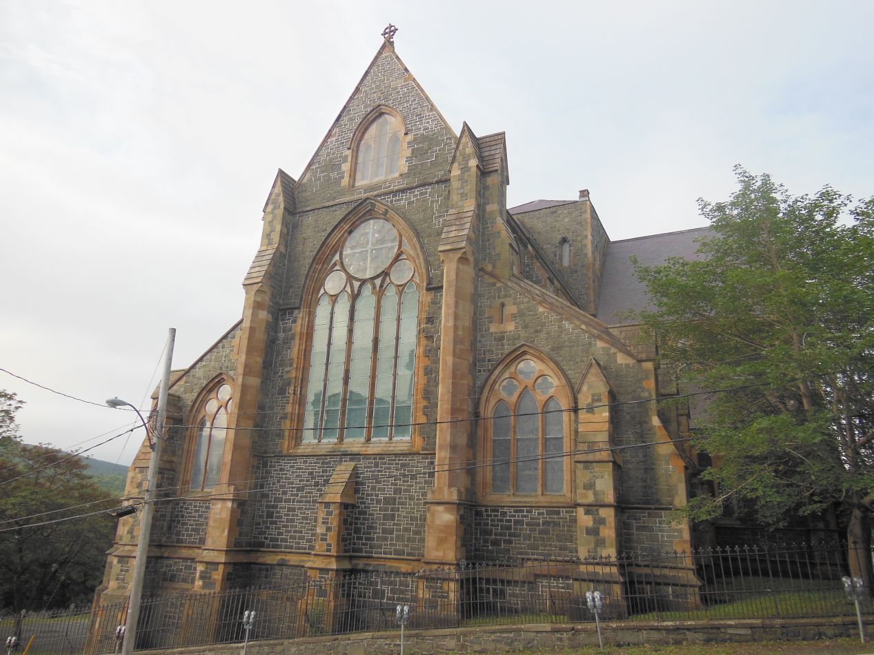


Switching to a completely different subject, here were a few pictures of some of the churches that I spotted in the downtown of St. John's. The first two images were from the Anglican church known as St. John the Baptist, depicting a Gothic structure first built in 1847 but not completed until several decades later. The Anglican community in St. John's dates back to 1699, and this current church is the seventh one to stand on this spot, with the first six all being wooden structures that burned down over time. The stone building looked weathered and worn as I walked past in the morning sunlight. The other church is a Catholic one known as the Basilica of St. John the Baptist. Yes, these two churches share virtually identical names and are located about three blocks apart from one another. I'm sure that never causes any confusion. The Basilica is the head of the Catholic church in Newfoundland and dates back to about the same time as the Anglican church in the mid-19th century. The architectural style is different though, favoring Romanesque design instead of Gothic. I would have loved to see the interior of these two structures, but they were both closed due to the early hours, and I wouldn't have time to come back later when they did open. I had to settle for viewing the exteriors alone.


It was a similar story at the Rooms, which was also closed when I walked past it. The Rooms is an art gallery and cultural center that serves as one of the most popular tourist attractions in the city. The building's name is a reference to the simple gable-roofed sheds that were once so common at the waterline in Newfoundland fishing villages. This was another place that was under construction at the time of my visit, and the torn-up entryway made the view a lot less attractive than it otherwise would have been. A visit to the Rooms had to be sacrificed due to lack of time; I had to catch a ferry back to the mainland in the late afternoon, and there were still other places I was trying to see before I had to drive to the boat landing.

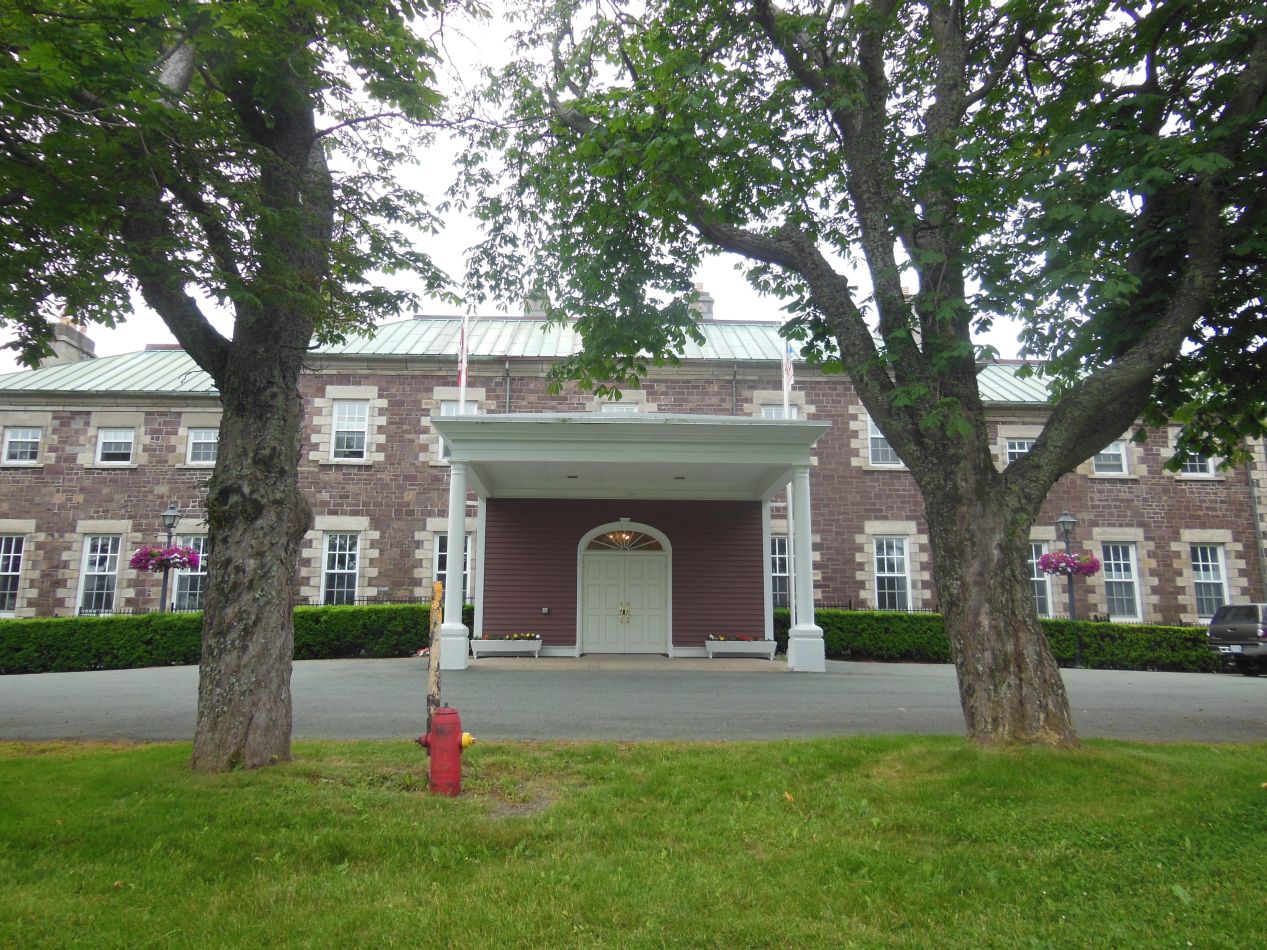


Before leaving the city, I stopped to see several more of its government buildings. The first pair of these were right next to each other, the Colonial Building and the Government House. The Colonial Building was the home of the provincial government of Newfoundland from 1850 to 1959 when it moved to a significantly larger site. This structure was tiny and it was hard to believe that the whole province had been administered from this spot for more than a century. The nearby Government House was the cherry-colored stone building shown above, and this is still where the Lieutenant Governor for Newfoundland resides. The Lieutenant Governors and the Governor General are uniquely Canadian positions, appointed by the British monarch as ceremonial representatives that hold no real power. The Government House building itself dates back to 1830, and some of the furnishings come from a previous version of the governor's house from even earlier. Finally, the much larger structure is the Confederation Building, the home of the current government of Newfoundland and Labrador. It was under construction at the time and didn't have much to recommend it from an architectural point of view. All of the places were closed since it was still Saturday morning, and I might have better spent this time by going to see other attractions. Hindsight is always 20/20 though.


Part of the reason why I was touring around St. John's in the morning was so that I would have time to visit Cape Spear in the early afternoon. Cape Spear is located only a few miles to the east of St. John's, housing a park and a historic lighthouse at the end of the cape. On a nice summer day, Cape Spear serves up beautiful views of the surrounding Atlantic waters and opportunities to spot whales and occasional icebergs floating down from the north. When I visited Cape Spear, however, the weather was proving exactly why a lighthouse was necessary. The whole peninsula was wrapped in a dense fog that made it difficult to see any distance, and even though the ocean was only a short distance away, I wasn't able to see much of anything out in the water. I liked the atmosphere here: it was mysterious and somewhat spooky, perfect for visiting an old lighthouse.


There are actually multiple lighthouses at Cape Spear. The building with the red-and-white striped dome is the historic lighthouse, dating back to 1836. It was changed a number of times over the years and then eventually restored back to its original appearance after the lighthouse was retired from active use. This is Newfoundland's oldest surviving lighthouse. The taller lighthouse is the one that remains in active use, dating from the early 20th century. It's been fully automated today, but the conditions on this foggy day made it clear why this rocky cape still needed a lighthouse of some kind. In addition to the visible light shining out into the mists, Cape Spear also kept sounding a thunderously loud foghorn every few minutes. I didn't see any mention of this in the visitor reviews of the place on Google, so this must be something that only happens on really foggy days to let approaching ships know that the coastline is up ahead. At least they did give some warning ahead of time on the signs.


The 19th century historic lighthouse has been opened up to visitors, and the whole interior is a reconstruction designed to look as it would have back when a lighthouse keeper lived on the premises. There were about half a dozen rooms to walk through on the grounds, including a trip up the stairs to where the light would have been located. The original lighthouse was built before the advent of electrical power, and it would have required huge mirrors to magnify the glow of the fire. I was fortunate that the lighthouse wasn't too crowded, again probably because of the weather, and I had plenty of time to walk through the grounds exploring the rooms one at a time.


Cape Spear was also in active use by the Canadian military as recently as World War II. The North Atlantic was the central focus of the German submarine effort to disrupt Allied shipping, and St. John's occupied an important strategic position for ships preparing to make the run across the ocean. This battery was actively manned by a battalion of the Royal Canadian Artillery for several years until the conclusion of the war, and some of the guns are still here to be viewed. The old battery had fallen into disrepair by the time of my visit, and sadly there was some graffiti back in the bunker where the servicemen had lived. I read online that this area has been fixed up since my visit in 2013, and hopefully anyone who visits now will have a more appealing area to explore.


Cape Spear is known for more than just the lighthouses and the WWII battery, of course. Cape Spear holds the distinction of being the easternmost point in North America at 52 degrees and 37 minutes west longitude. That's a long way to the east of anywhere in the United States, and Americans have a habit of thinking that the land comes to an end somewhere just east of Maine. This is not helped by the fact that we all grow up with maps displaying the 50 states, with all of Maritime Canada cut off the edge. When I talked to my family on the phone during this trip, they were surprised to find out that I was 1.5 hours ahead of the Eastern time zone; generally, we tend to think that there's nothing beyond the Eastern time zone until reaching Europe. In truth though, it's possible to go a long way before reaching the edge of North America. Cape Spear was fully 25 degrees of longitude to the east of Washington DC; if I went the same distance to the west, I would be sitting on the Kansas/Colorado border. Cape Spear and St. John's are that far east.
This was the true finishing point of my journey, at the literal end of the North American continent. It was impossible to travel any further east without hopping on a plane or a boat. The land at the tip of Cape Spear ran down onto a series of rocks that ultimately fell into the sea. There was a small cross at the end of the pathway just above the rocks dedicated to those individuals who had lost their lives here; Cape Spear has dangerous tides and a number of people have drowned in the area. Visitors were strictly warned to stay out of the water and avoid the slippery rocks along the coast. I couldn't help but feel that this was the perfect spot to bring my trip to a close. It was misty and raining and I could hear the pounding of the surf as the waves lashed up against the rocks. I had wanted to travel to the utmost ends of Canada, and I had achieved my goal.
Now there was just one problem: I was still sitting on Cape Spear, and I had a loooooooong return trip ahead of me.

Yep, there's the intimidating journey detailed above, a distance of some 3000 kilometers / 2000 miles at rough estimate. It wasn't quite as bad as displayed here because I was able to take the summer ferry that leaves from the south of the Avalon peninsula at Argentia rather than having to go back to the western year-round ferry at Channel-Port aux Basques. But this was still pretty darn bad, there was no getting around the extreme distances that I had ahead of me. I started out by making the two hour drive from Cape Spear down to Argentia, making sure to arrive several hours before the ferry was scheduled to depart. This one was going to be leaving in the evening and run through the night, taking about 12 hours to reach the same place where I had originally embarked at North Sidney on Cape Breton Island. I was tired enough that I didn't take a lot of pictures of this ship, just one while waiting for the loading to begin:

Fortunately it was another smooth passage, and I was able to get some relatively decent sleep on the voyage back to the mainland. The next morning, when I arrived back in North Sidney, I still had a very long drive ahead of me. I had booked a hotel room in Portsmouth, New Hampshire in the hopes that I would arrive in the evening and have time to explore the small city a bit. I've never done more than drive through Portsmouth and it's supposed to be a pretty place to visit. However, the drive from North Sidney took 12 hours to complete and covered about 1200 kilometers / 750 miles in total. While I did arrive by about 7:00 PM, I was completely and utterly exhausted by that point, one of the most tired states that I can ever remember being in. I didn't want to do anything more than eat dinner, take a long shower, and go to bed. The remaining drive the next day wasn't as bad, this time only requiring about 7-8 more hours as I headed back through New England and the mid-Atlantic states to Baltimore. Doing a trip like this really puts things in perspective; I found myself thinking "wow, it's so crowded here in Maine!" since the state was indeed a lot more populated than places like Newfoundland and Cape Breton. Everything is relative.
Here's the final mileage comparison on my rental car:
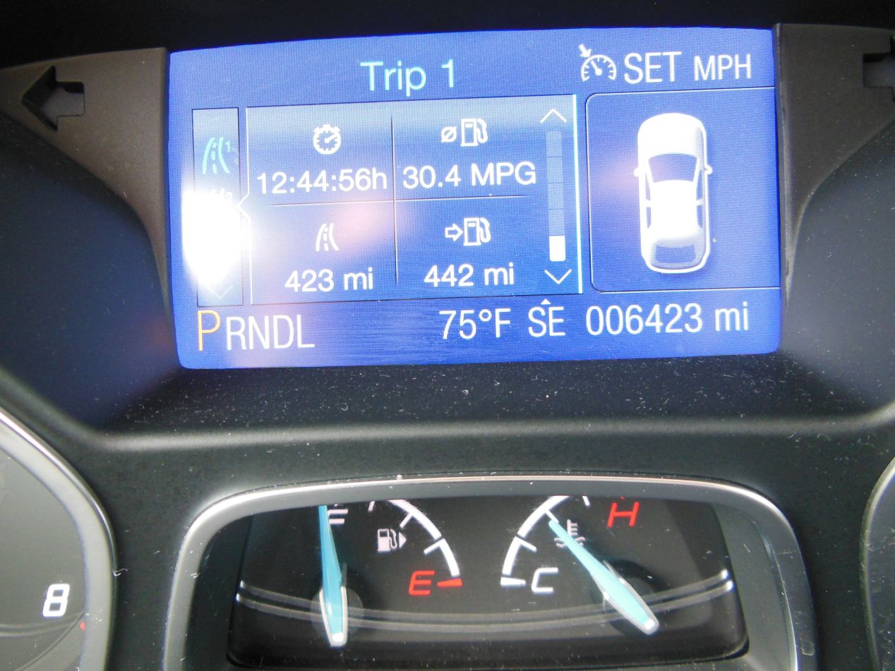

Remember how I made sure to get "unlimited mileage" on my rental car? I don't think they expected me to do something like this.  I put a grand total of 5074 miles (8166 kilometers) on this car in 15 total days of driving, all of that solo. I'm still not exactly sure how I managed to pull that off while doing all this sightseeing at the same time. It was a marathon trip that left me completely drained afterwards, and I needed to spend the next week recovering from the ordeal. It was worth it though, as this had been a magical trip to places that I never expected to see. I hope anyone reading enjoyed having the chance to see some of these same magnificent locales. Canada is a beautiful country, and it's easier to visit than most Americans seem to think. Hop in a car and get out there exploring! As always, thanks for reading.


