
In the last section of this trip, I detailed how I spent a day visiting the remote stretches of the Labrador Coast. Afterwards I returned back to Newfoundland again, recrossing the same Straight of Belle Isle to the northwestern tip of the island. This page collects together some of the attractions that I saw while exploring the western and central parts of Newfoundland before heading on to the Avalon peninsula and the city of St. John's. This included several idyllic small towns, a wind-tossed hiking trail along the coast, a colony full of puffins, and a whole bunch of Viking stuff. Yes, actual Vikings of the Scandinavian type.  Keep reading and it will all make sense.


As mentioned above, I took the early morning ferry back from Blanc Sablon to St. Barbe, the reverse of the trip that I had done the day before. This was the early morning ferry and it was more crowded than the midday ferry from the previous day. After an uneventful passage, I began driving further to the northeast on the island of Newfoundland. I was heading for L'Anse aux Meadows National Historic Site, a small preserve on the spot where Viking adventurers landed in North America around 1000 AD. I had read about L'Anse aux Meadows many times in different history books over the years, and this was a place that I always hoped to visit someday. Unfortunately it's extremely far out of the way, at the extreme northernmost tip of the island of Newfoundland and a two hour drive from the ferry at St. Barbe... which itself was way out in the middle of nowhere. To give you an idea of the remoteness of L'Anse aux Meadows, the largest town for a hundred miles in any direction is named St. Anthony, and this "big town" has a population of 2400 people. I made the drive along the so-called Viking Trail and took a picture of the sign proclaiming that this was the Vinland of the Viking sagas. According to current research, Newfoundland likely was not the legendary Vinland, which probably referred to areas further south in New Brunswick. Nonetheless this was a pretty area, with very small hamlets of a dozen or two houses perched along the coast, and brilliant blue from the sky and the water accompanying them on all sides.

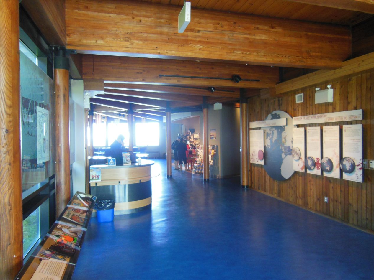


Eventually I arrived at L'Anse aux Meadows a little before noon. Discovered in 1960 by archaeological excavation, this is the only confirmed location of a Viking camp in North America. The initial discovery was made by the Norwegian husband-wife team of explorer Helge Ingstad and archaeologist Anne Stine Ingstad, who worked from the old Viking sagas and managed to figure out that the northern tip of Newfoundland was a likely place for a Viking base camp of some kind. Working with local people living in the area, they carried out a dig on this spot and determined conclusively that it was created by European visitors, not the indigenous people living in the area. Tourists who come here today are greeted with an excellent visitor center with information about the Viking settlement on the spot. I particularly liked the model above that reconstructed what the camp might have looked like. The current best theory is that this was not a permanent living spot, but rather a supply camp for expeditions passing back and forth between the larger settlement in Greenland and destinations further to the south. In other words, this was more of a boat repair facility than a colony where people came to live.

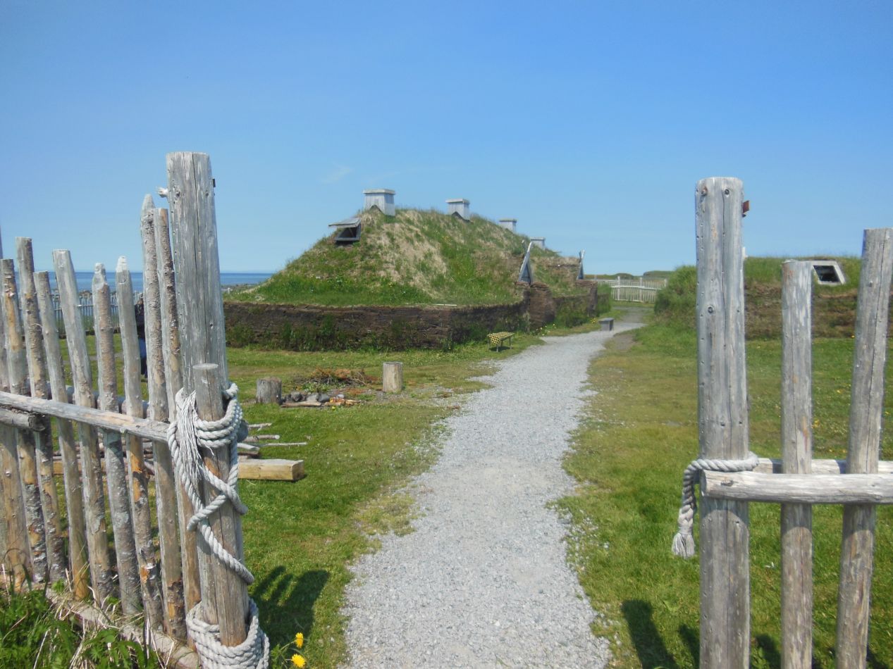


After poking around in the museum for a little bit, I headed outside to view the location of the archaeological dig. A staircase and a series of wooden platforms led down to the grassy area near the coast where the ancient camp had once been located. Even though it was a beautiful cloudless day outside, this was still a pretty desolate location with rocks all over the place and no trees visible for miles. I continued to have the impression that winters in this part of Atlantic Canada are absolutely brutal. Further down the trail were a series of reconstructed buildings designed to look like the rough dwellings thrown up by the Vikings. These little buildings were made out of sod and had grass growing out of their roofs. Cheap to make and quite warm inside, perfect for the climate.


Here are two pictures of the interior; unfortunately the first one came out a bit blurry. There was a guide inside wearing period costume who was explaining about the settlement and the buildings that were constructed here by the Vikings. The setup inside was a bit idealized, and I suspect everything would have been a lot dirtier and more ramshackle in reality. Still, the historical site did a fantastic job of constructing these buildings to give a sense of what the camp would have looked like roughly a thousand years earlier. Otherwise, there would have been nothing but an empty field to view.


Speaking of empty fields... The reconstructed buildings are naturally set a little bit off to the side from the location of the archaeological dig itself. The actual spot of the Viking camp is pictured above, and of course none of the original buildings survived the long centuries of intervening time. Sharp eyes can spot the indentations in the ground where the buildings were placed, and where they were excavated by modern researchers before being restored back to their current condition. The archaeologists found lots of iron nails and miscellaneous small objects that could only have come from European visitors, which was enough to confirm that the Vikings had indeed been here. The best view of what the camp would have looked like is probably the little model from the museum that I pictured above. You have to use a bit of imagination today to see it, either that or focus on the reconstructed buildings off a little bit to the side. Overall, this was a really neat place to visit for anyone who enjoys history or archaeology. While I'm not sure it's worth a trip this far out into nowheresville, for anyone who might be in western Newfoundland, definitely try to make it up here to check out L'Anse aux Meadows.


One of the places that I stopped while driving down the coast of western Newfoundland was at this small local park called "The Arches". It refers to a natural rock formation where the water slowly carved out a series of natural tunnels over milennia. They do indeed look like human-built arches, and this was a nice place to stop and stretch my legs for a few minutes. I was doing a lot of driving - Newfoundland is a big island and these places that I'm describing are pretty spread out from one another. In reality, I went back to Gros Morne from this point and then spent a day hiking and taking a boat tour of one of the local fjords. Since I already described those activities back in the Gros Morne section, I'll skip ahead another day at this point and get back to the exploration of Newfoundland outside of Gros Morne.

To provide an idea of the distances involved, here's the zoomed out map of the island of Newfoundland. Channel-Port aux Basques in the extreme southwest is where the ferry from Cape Breton Island had arrived, and Rocky Harbor is situated in the center of Gros Morne National Park. L'Anse aux Meadows in the far north where was I had just visited, and I was heading next to the Bonavista peninsula in eastern Newfoundland, before finally traveling to St. John's and the Avalon peninsula afterwards. There was a lot of driving involved in getting between these places, an awful lot of driving. Remember that I had already driven from the Baltimore area up through the whole St. Lawrence valley and then across virtually all of Maritime Canada before reaching Newfoundland. This hard traveling was taking its toll on me, and I was starting to wear down from so many days of non-stop driving and sightseeing. But I was getting close to the finish now, and I was determined to finish up my trip strong. There was a lot still to see in central Newfoundland before I reached the eastern edge of the island.

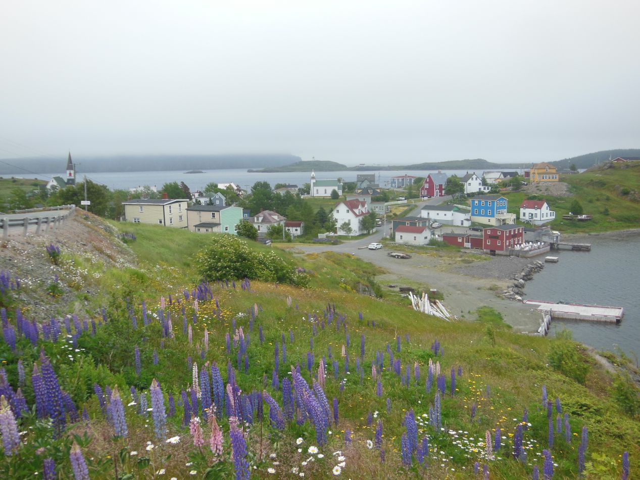


My first stop on the Bonavista peninsula was at the historic town of Trinity. This small town is located on its own little peninsula that sticks out into a sheltered harbor, and the area has been in use by fishermen since the middle of the 16th century. Trinity has never been a large town and the population in 2015 was listed at only 170 people. However, Trinity's quaint location causes it to attract a good deal of tourists in the summer, who are drawn here to experience whale watching tours, stay in some of the cozy bed and breakfasts, or even watch a performance in the local Rising Tide Theatre pictured above. The colorful small houses nestled up against the coastline couldn't be more quaint, and I spent about an hour wandering around to explore the area. It was unfortunate that the weather had finally turned on this day, and the clear blue skies had been replaced by oppressive gray clouds. They kind of fit the area too, however, as all of the little towns along the Newfoundland coast get ample amounts of rain throughout the year.

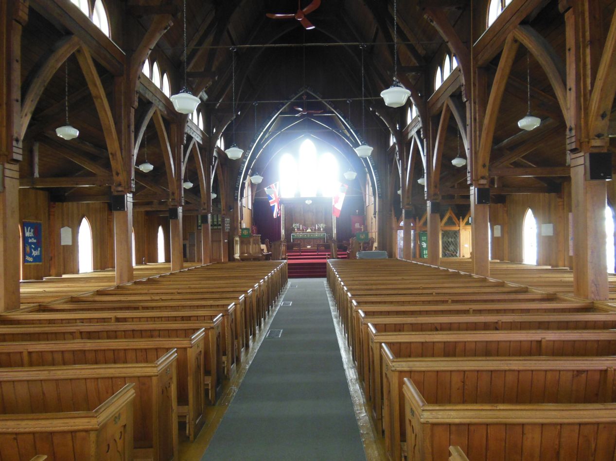


Another attraction in the town was this wooden church known as St. Paul's. This was an Anglican church that dated to 1892, the third one to be built on this spot with the previous incarnations dating back to 1821 and 1730. St. Paul's seemed to be made almost entirely out of wood, with wooden pews, wooden beams, and a wooden ceiling overhead. It had a warm feeling inside though and felt like the kind of place inhabited by a small and tightly-knit community, one of those places where everyone knows everyone else by sight. With the British and Canadian flags flying together over the altar, this almost could have been a church frozen in time from the colonial days. There was one other object of note inside: a framed floor plan listing all of the pews and the families that used them dating from 1894. I suspect that some of the same families are still using them today, as this seems like the kind of place where not much changes over the years.

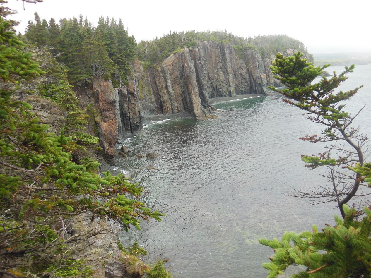


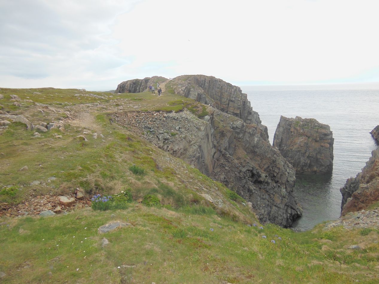
After leaving Trinity I headed to another nearby attraction, the hiking path known as the Skerwink Trail. This is one of the most highly rated hiking trails not only in Newfoundland, but in all of Canada, a short 5 kilometer (3 mile) walking trail that follows along the cliffs at the end of Dog Cove to the Skerwink Rocks at the water's edge. I had a little trouble finding the entrance to this trail, and if it hadn't been for the signs and the nearby parking lot, I never would have known that this was the trail's beginning. The initial part of the path followed through what looked to be the backyard of private houses. It was still overcast outside and the trail soon entered into a forest of short evergreen trees. After about 1 km the trail reached the coast, however, and the scenery became a lot more interesting. A series of steep cliffs fell away below to narrow rocky beaches with dark gray sands. It was a starkly beautiful view, a place that captured the rough character of the Newfoundland coast.

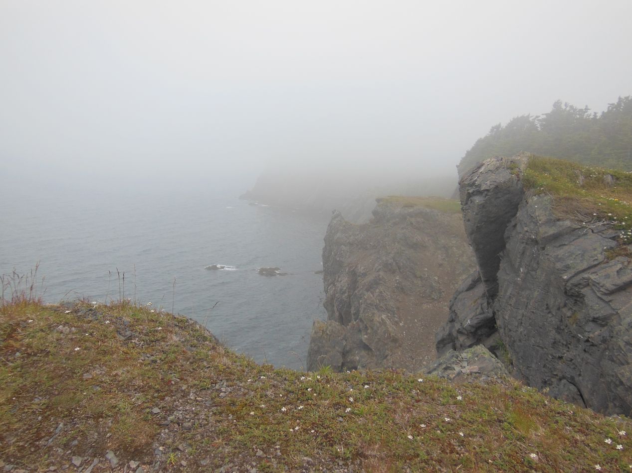


The trail seemed to be getting wilder as I proceeded further. Perhaps it was due to the weather, as the clouds closed in and shrouded the whole coastline under an enveloping mist. The wind was whipping in off the water and I could hear the surf crashing up against the rocks. At one point, I had to walk up a staircase on a steep hill with grasses falling away off the cliff's edge to my left. At other places I was able to stand at the ledge of a cliff, with the chance to look down into the slate-gray waters below. There were a couple of other people on the Skerwink Trail, but mostly I was alone to wander through the mists. This was a fantastic experience and I can see why the trail is consistently rated so highly by visitors.  It only took about 90 minutes to do the walk at a leisurely pace and the views were simply spectacular. I feel as though this was one of the most authentic parts of my Newfoundland trip in terms of getting a true sense of the area.

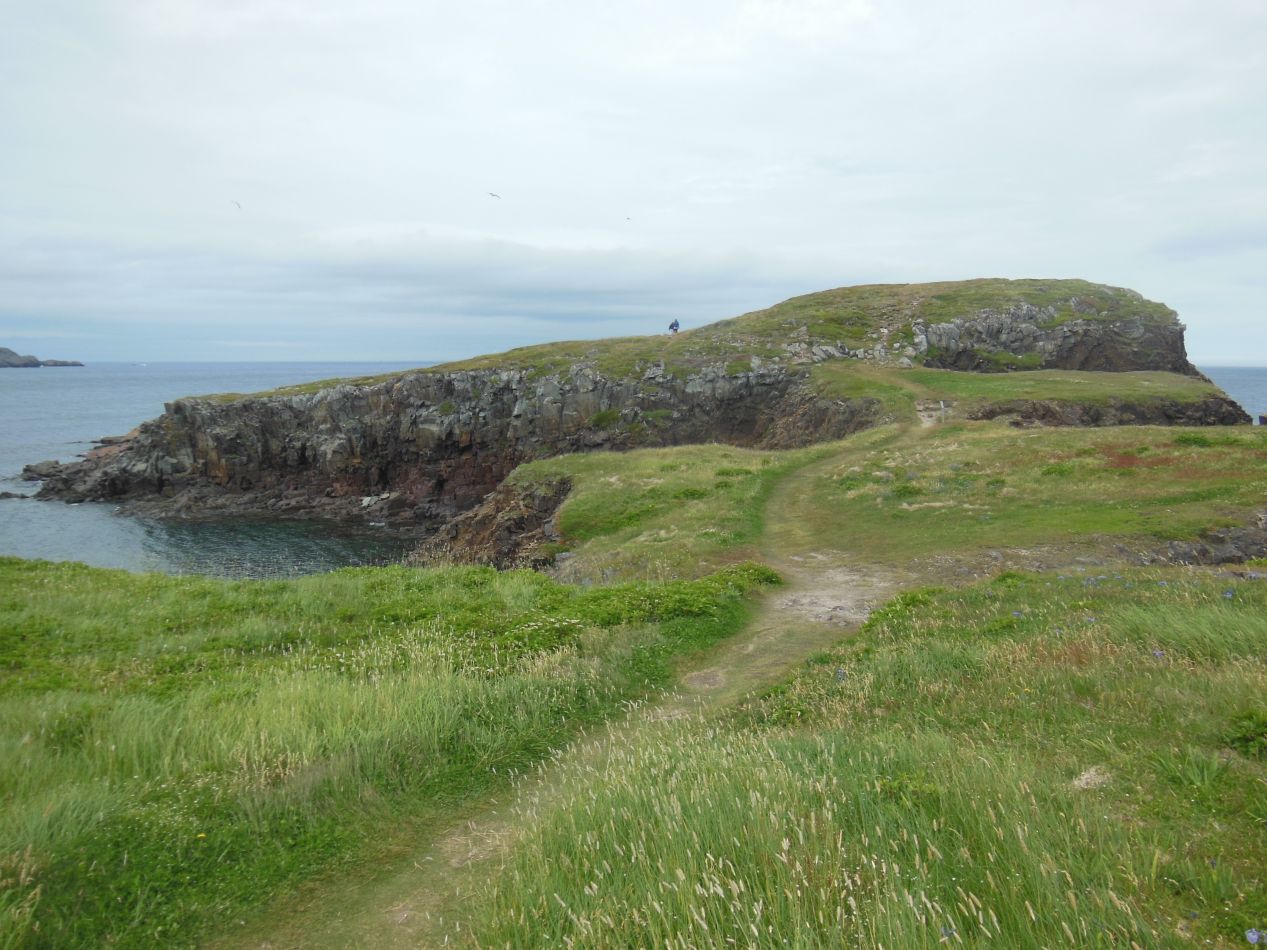


The next place that I headed was a bit further north on the Bonavista peninsula, to a small town named Elliston. This place advertises itself as the "Root Cellar Capital of the World", and although that may be true, I was here to visit the local puffin colony on the rocks offshore. The puffins had their nesting area a little bit to the east of the town proper, on a head of land that jutted out into the surrounding waters. Amusingly enough, the two nearby islands are listed on Google maps as "North Bird Island" and "South Bird Island" for obvious reasons. I followed the path from the road onto the rocky headland, which looked a bit like the training planet (Ahch-To) featured in Star Wars: The Last Jedi. That made sense, since the adorable "porgs" from that movie were largely based on puffins anyway. From this spot, I had a great view of the huge puffin colony:

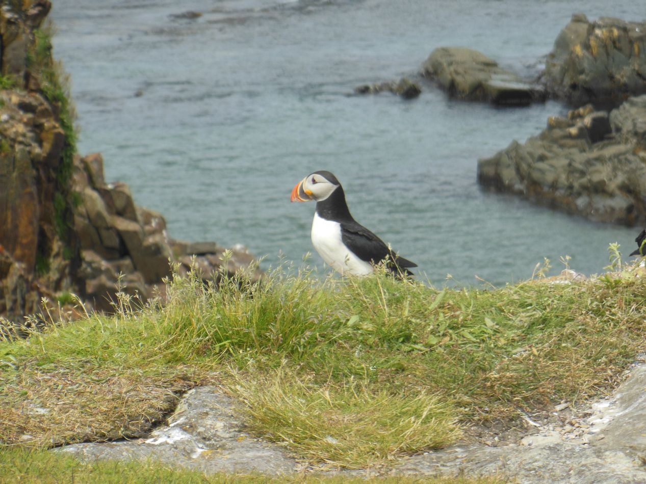


The birds were really cute when seen up close. There were hundreds and hundreds of them here, possibly even thousands of them dotting the rocks. Unfortunately this meant that the rocks out where the birds nested were covered in their white droppings, although the wind and water from the nearby ocean kept things from getting too disgusting. It didn't smell at all with the wind blowing constantly in from the water. There were several other people here just watching the puffins and relaxing, one person sketching them in a notebook, that sort of thing. This was a time when I wished that I had brought binoculars to watch the birds more closely.


From Elliston, it was a short drive to the tip of the Bonavista peninsula where a lighthouse was located. This one wasn't as pretty as many of the other lighthouses I had seen, and it looked like it badly needed a fresh coat of paint to repair the damage caused by the elements. However, this is one of the oldest remaining lighthouses in Canada, dating all the way back to 1843, and much of the interior of the original lighthouse has been preserved intact for visitors. I arrived too late in the day to see the interior of the lighthouse and had to be content with exploring the surrounding area. There was more than I expected to see here, including a statue to dedicated to the explorer John Cabot:


According to legend, the Bonavista peninsula is the location where Cabot first landed in the New World. There's no evidence to indicate this, however, and the explorer could have landed somewhere else just as easily. I felt an odd attachment to John Cabot since I had previously seen a modern recreation of his ship in Bristol, England from which he set sail, as well as having previously visited another small park in Cape Breton Island that locals claim as the "first landing" spot in North America. The ambiguity apparently lets multiple places claim that honor. This particular location had a statue dedicated in Cabot's honor and which was in much better shape than the nearby lighthouse. Perhaps it was a new addition. The surrounding area was extremely rocky, with slabs of some kind of stone slanting at jagged angles down into the water. There were cliffs with climbing opportunities everywhere and this would be a spectacular place to bring older kids so long as they could be trusted not to do anything too crazy. What little vegetation existed here seemed to be tough strains of moss and scrub grasses that could survive the constant rain and wind up here on the rocky grounds. It was a really fun area to explore, and made for a satisfying conclusion to the day.
From here, I drove on to the only major city in Newfoundland, St. John's, where I would be staying for the night. En route, the skies finally opened up and let loose a torrential downpour that dropped visibility to near-zero. This made the drive over to St. John's a difficult and somewhat dangerous affair until the storm finally broke about two hours later. I wish I could have taken some pictures, but I was driving the car and concentrating on not crashing. You'll have to take my word for it. The final part of this travel journey picks up in St. John's, as I explored the city and the surrounding Avalon peninsula.


