
These are pictures from my visit to the state of Minnesota over the course of a week in the summer of 2014. I went on this trip with my family and it was a welcome opportunity to take a short break from my ongoing job search. The year of 2014 had mostly been a frustrating one for me; I was still teaching history classes part time at a local community college, and I spent most of the year unsuccessfully applying to hundreds of jobs without getting any interest in response. It was depressing to see how little most employers seemed to care about the Ph.D that I had spent most of the previous decade earning. This trip was the chance to get away from the mundane drudgery of searching online job postings and filling out application forms. Aside from flying through the airport on a transfer connection, I had never been to Minnesota before and was looking forward to getting the chance to see a good portion of the state. We had plans to spend several days in the Minneapolis / St. Paul area, and then drive north to Duluth and poke around in the Lake Superior region. This trip was exactly what I needed.

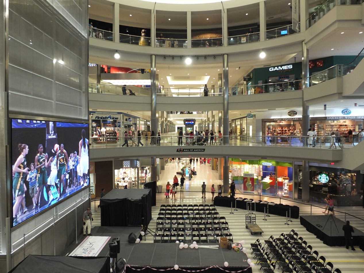


Our flight from Baltimore touched down in the early afternoon and we headed to our hotel first. Because our hotel turned out to be located very close to the Mall of America, this crowning monument to capitalism ended up being the first attraction that we visited. The Mall of America is the largest shopping mall in the United States and among the largest in the world, although its ranking has been slipping as more gargantuan shopping centers have been opened internationally. It opened in 1992 and was built on the site of the former Metropolitan Stadium, where the Twins and Vikings played before the Metrodome was constructed. The mall encompasses 96 acres and hosts 530 stores according to the information on Wikipedia. This is a really large building, as demonstrated by the four floors of shopping that we saw immediately upon entering. There was a huge screen with a Minnesota Lynx game (the city's WNBA team) sitting behind a stage, and the whole setup was swallowed up by the giant open spaces inside the mall. Most of the stores are located on one of the four floors in the circular corridor surrounding the central enclosed area. That's the home of a small Nickelodeon-themed amusement park, complete with multiple roller coasters. It can all be overwhelming for first time visitors.

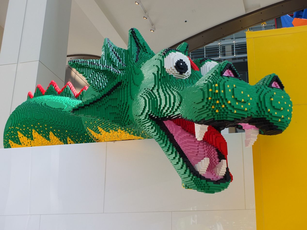


We ate lunch at one of the two dozen restaurants located within the mall, then spent an hour or two wandering around to take in the sights. This is a place of huge excesses in consumerism, with every store trying to be bigger and flashier than its peers. The Lego store was probably the best of the lot, with several enormous sculptures made out of the tiny plastic bricks. This Gundam-style robot was about 15 feet tall and must have had tens of thousands of Lego pieces. In addition to selling everything Lego-related under the sun, the store also had a free play area where kids could experiment with the toys to their heart's content. That was nice to see. Elsewhere, we walked past the small aquarium that the mall hosts, as well as the 500 room hotel tucked into one of the corners. (Not where we were staying!) Then there were the things on sale that were simply zany: gluten-free gourmet dog treats? An upscale barber shop called "The Art of Shaving"? Zip lines and midway carnival games in the central amusement park area? It was all a little bit too much. The attractions generally felt overpriced for what was being offered; we're a bit of connoisseurs when it comes to miniature golf from having played so many courses over the years, and the mini golf on display at the Mall of America was not worth the asking price. All in all, I would say that it's worthwhile to see the Mall of America for the sheer spectacle that it represents. However, this was not one of my favorite places that we visited on this trip, and it would be pretty far down my list of places to go in Minneapolis. At the end of the day, this is essentially a really big shopping mall, and how one feels about malls will dictate feelings about this attraction.

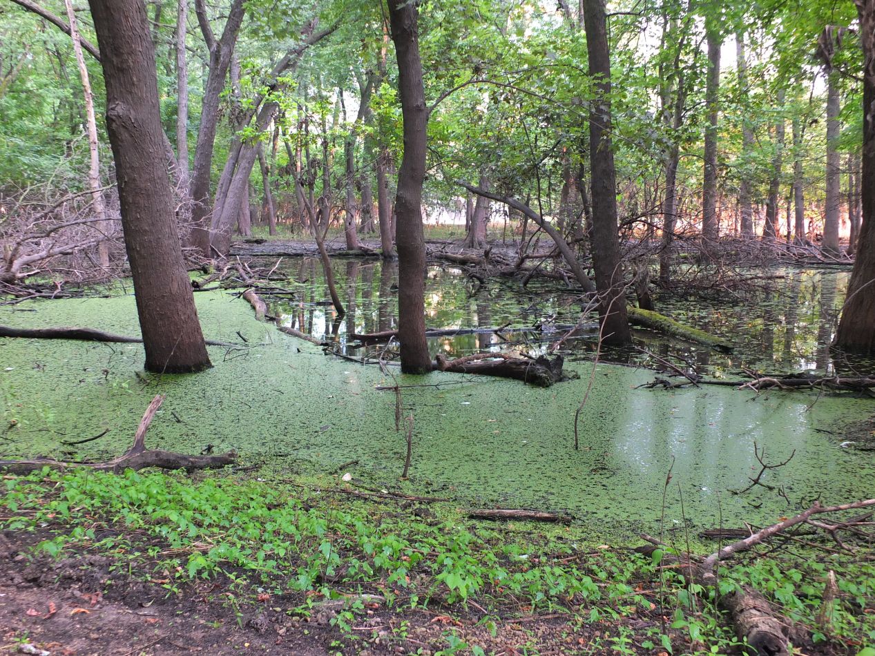


We ended the day by stopping to walk along some of the trails in nearby Fort Snelling State Park. It was quiet there along the banks of the Mississippi River, with hardly anyone else present. This was a huge contrast from the hustle and bustle of the crowds in the Mall of America only a short distance away. Most of the terrain along the river was swampy in nature, and aside from the foliage reflecting a cooler climate, this could have been a scene out of the bayous in Louisiana. We also had the good fortune to spot a wild turkey that scampered into the brush on approach. With the sun setting in the distance, this was a relaxing way to close out the day.

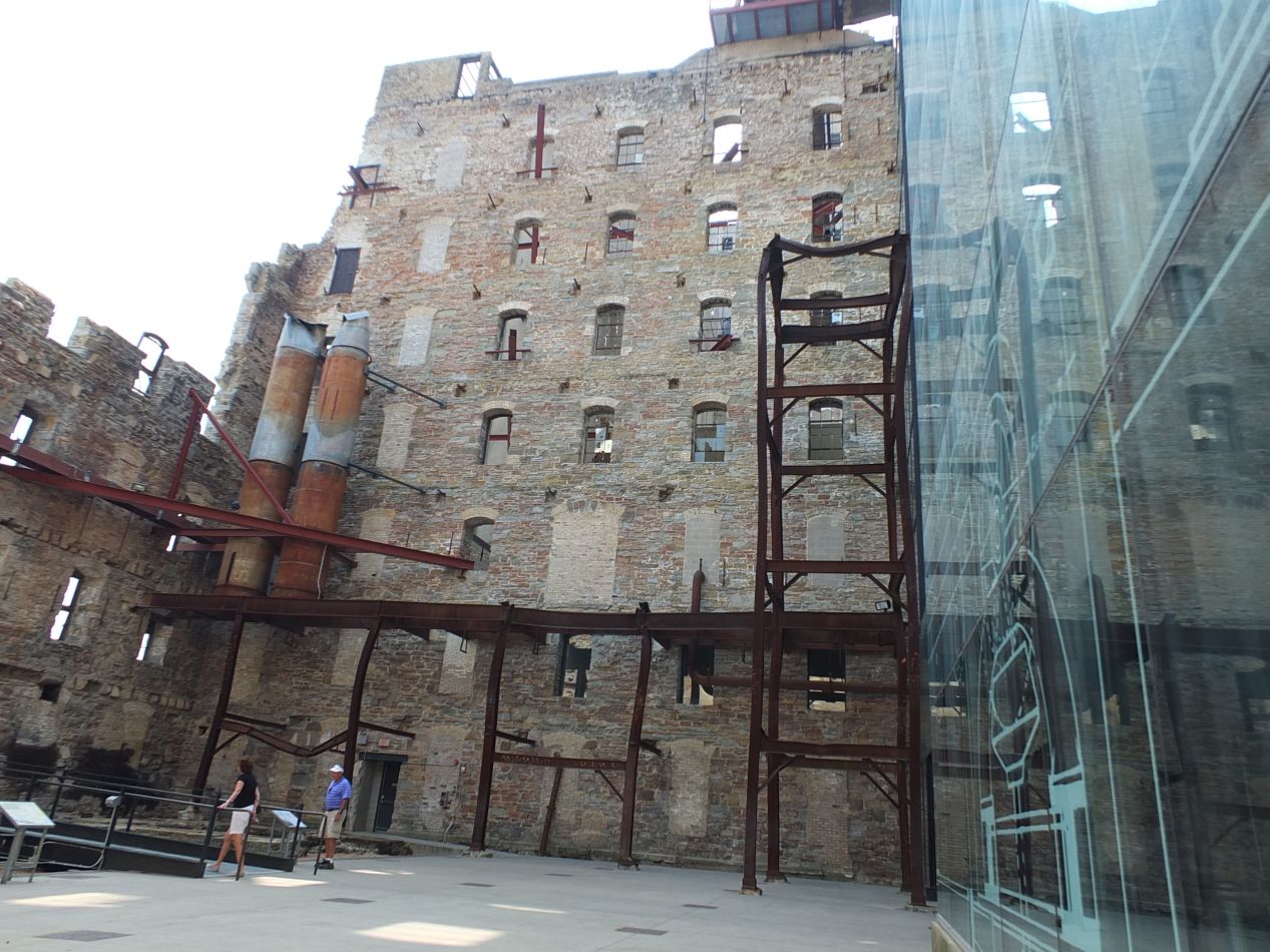


The plan for the next day was to drive into downtown Minneapolis and explore the sights in the city. Our first stop was at the location pictured above, the Mill City Museum, constructed in the ruins of a historic Gold Medal Flour processing mill. The Mill City Museum is dedicated to telling the history of the Gold Medal Flour company, and more broadly the history of industrial development in the city of Minneapolis. While this might sounds pretty boring, the museum does a fantastic job of exploring what life was like for industrial mill workers in the first half of the 20th century through various hands-on tours and exhibits. The building itself is an interesting combination of the original shell of the old mill building and a modern refurbishment. There was a terrible grain explosion in 1878 at the mill that killed 18 people and destroyed most of the original building, but the mill was rebuilt and designed to be protected against fire. This was one of the largest flour mills in its heydey before being shut down in the 1960s. The collections of the museum include a baking lab and all sorts of artifacts from the city's history. A lot of this stuff was interactive and great for kids; there was a summer camp coming through while we visited and the kids seemed to be having a good time, especially with the station that challenged visitors to build a bridge over a miniature river with wooden blocks and real running water. There was a lot more to see here than we had initially expected.

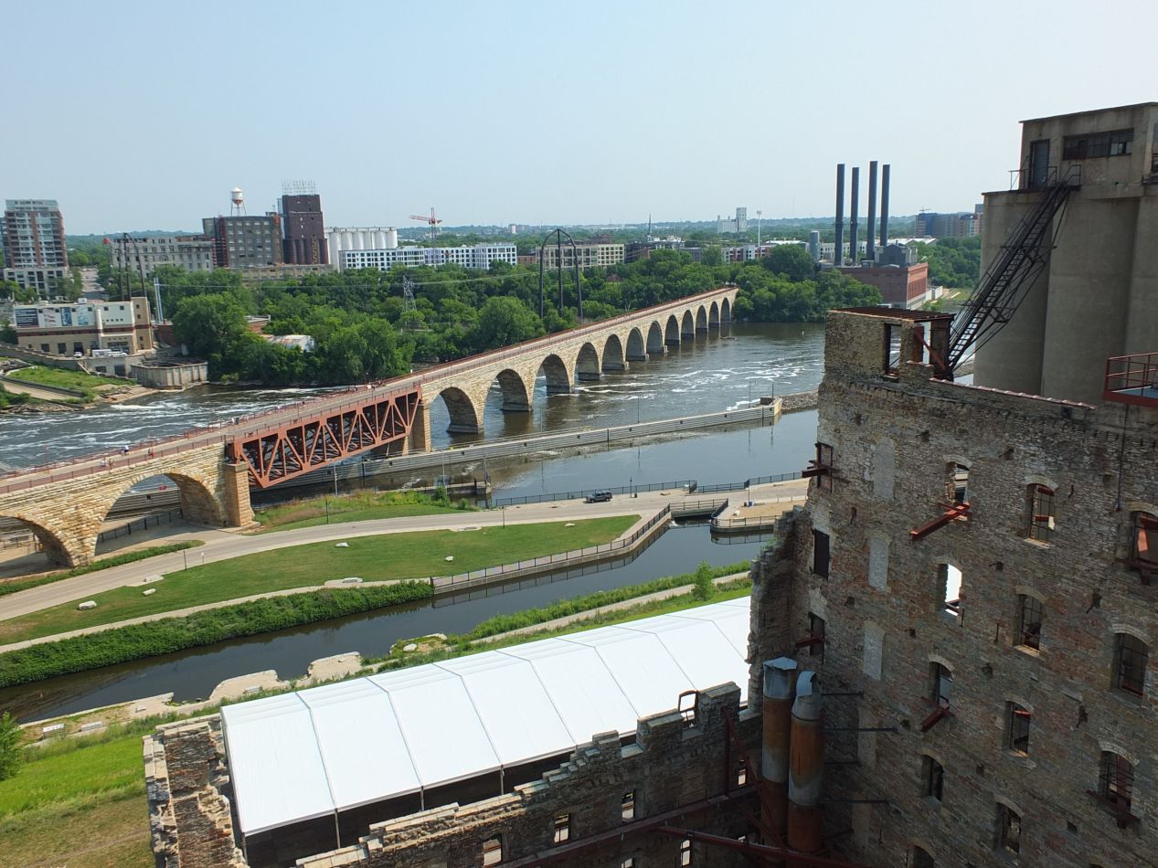


That wasn't even getting into the featured tour at the museum. Known as the "Flour Tower", this is a trip through an old grain elevation that takes tourists up to the top of the building. Along the way, a guide talks about the tasks that workers carried out in the mill when it was at the height of its industrial processing. While all of that was interesting enough, the real star of the show was the views of the city that opened up from the observation deck. We could easily see the Mississippi River and St. Anthony Falls, the little waterfall that caused a city to be built here in the first place. All of that running water was also excellent for industrial milling, and thus the reason why this structure had been built in this spot. We could also view the Stone Arch Bridge, the oldest one connecting the two sides of the river together. Even if we hadn't enjoyed the rest of the museum - and I should stress that we did - it would have been worwhile to come here for this vantage of the city.

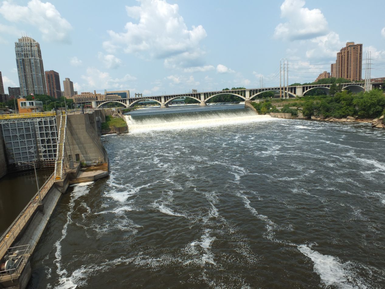


After walking past the Guthrie Theatre that stands next to the Mill City Museum, we headed over to St. Anthony Falls and the Stone Arch Bridge. The falls themselves are surrounded by a park of ruined mill buildings, the shells of past industry that died over time and left only shattered remnants of stone in their wake. This area has wisely been turned into a park by the city of Minneapolis, and today there's a walking and biking trail that runs along the riverfront. As for the falls themselves, they are much smaller than you might expect, and would likely pass unnoticed without the signs to point them out. This appearance can be deceptive, however, as the falls have been tightly regulated through a series of locks and dams designed to prevent flooding and keep the underlying limestone from eroding. The falls were also enormously important in the city's development, as they are the only falls of any size on the upper Mississippi. Without the presence of St. Anthony Falls, all of those mills and other industries would never have been built and the city of Minneapolis would never have existed.
As for the Stone Arch Bridge, it was originally a railroad bridge before being converted into the pedestrian walking and biking path in use today. The bridge was completed in 1883, and it was only the second bridge to span the Mississippi River following a slightly earlier bridge built in St. Louis. We strolled across the bridge at a leisurely pace, stopping frequently to look at the river and the buildings on either side. The view looking south towards the downtown portion of Minneapolis was the more impressive one, with a series of high rise structures towering up above the surface of the water. The north side of the river lacks those buildings and contains a public park instead. We crossed over to the north side of the river and ate lunch at one of the numerous cafes. Outside of places to eat and shop, there wasn't as much up there as we had been expecting, and after circling around to the west and crossing the river again at Nicollet Island, we prepared to head to our next destination.


We drove out of the city center to Minnehaha Falls a few miles to the southeast. This is the home to the waterfall mentioned in Longfellow's poem "The Song of Hiawatha", and it has been attracting tourists to the area since the late 19th century. The water runs through a narrow channel and falls about 50 feet to a pool below, with the roaring sound supposedly imitating the sound of laughter. Minnehaha Falls are located within the larger Minnehaha Park, which runs along the nearby banks of the Mississippi River and connects it to a series of lakes. My family loves to ride bikes and we rented some in the park to pedal about and explore the area. There were some beautiful houses in the area, especially along the banks of Minnehaha Creek. The walking/biking trail that ran parallel to the creek crossed over a series of low pedestrian bridges and bypassed several tennis courts. This looked like a wonderful place to live for anyone who didn't mind cold winters. The trail eventually led to Lake Hiawatha, one of the famed 10,000 lakes that dot the state of Minnesota. This is an area where glaciers in the recent geological past have left their mark, and lakes are indeed everywhere across the state. The water level was running high at both the falls and the lake, drowning the entrance to the dock pictured above. We were having good weather but it looked like it had been raining a lot prior to our arrival.


These last pictures were taken in the business district of downtown Minneapolis, where we had returned to get dinner for the evening. High rise buildings rose up on every side, and many of them were connected by indoor walkways for the cold portions of the year. There was no shortage of restaurants and shops to investigate here, all of the things that would be found in any large cosmopolitan center. The most unique thing that we spotted here was a statue of Mary Tyler Moore, in the famous pose from the TV show with her tossing a hat into the air. I'm too young to have watched that show, but the statue definitely stood out in an otherwise normal business district.

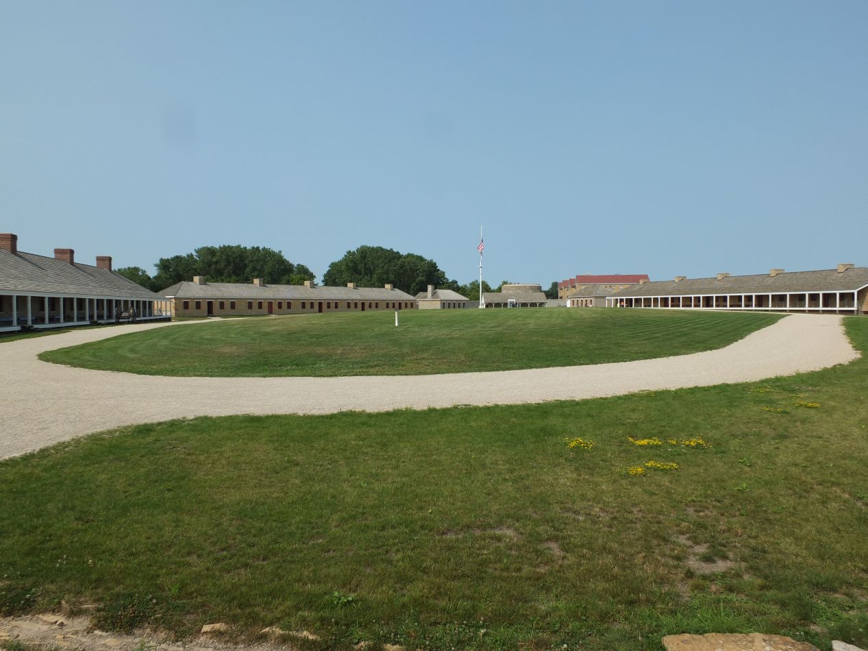


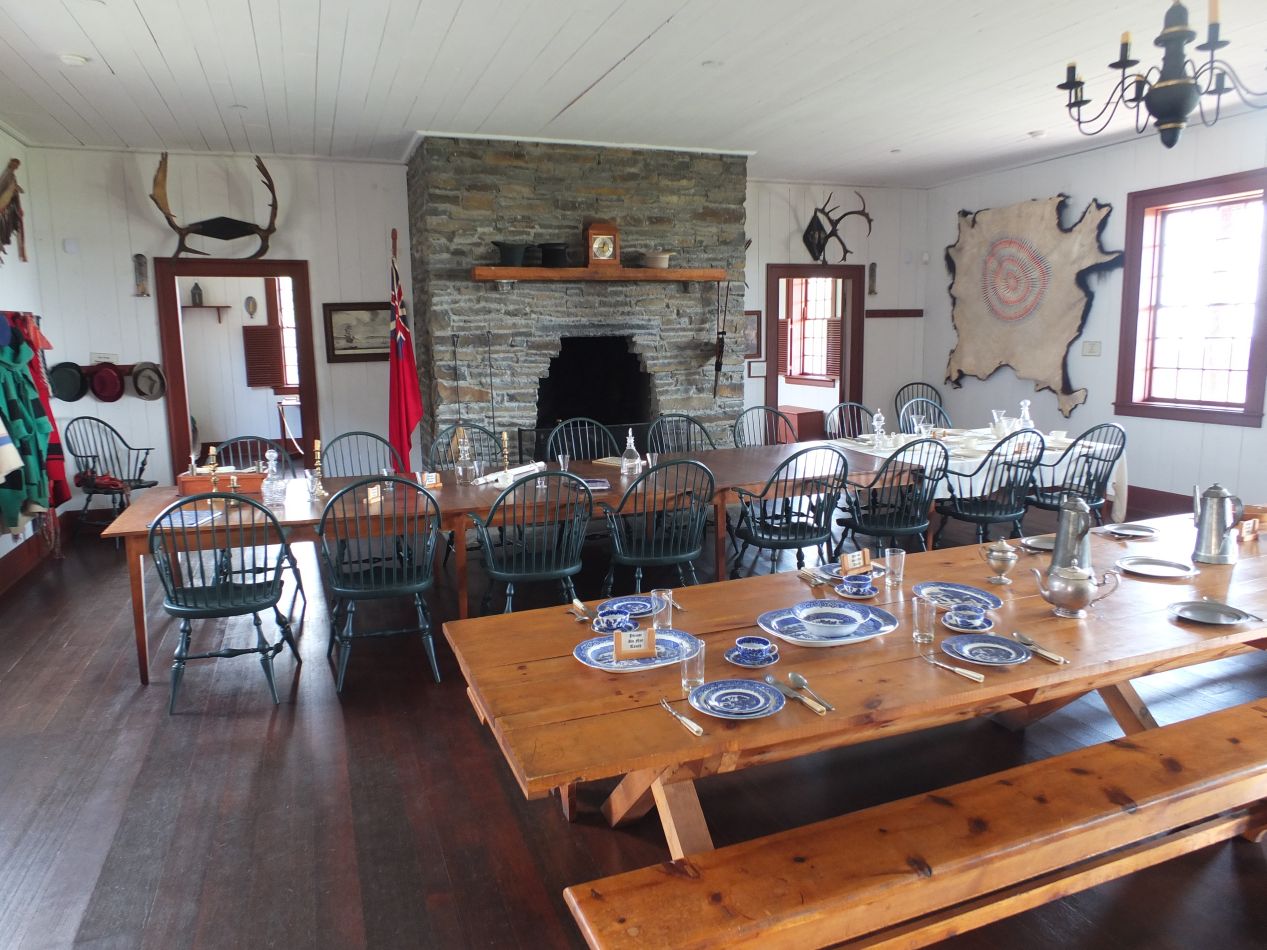
For our third day in the area we were heading over to St. Paul, the other partner of Minneapolis in the famed "Twin Cities". First we had to decided to visit Fort Snelling, however, the original military fortification that predated the establishment of either city. Fort Snelling (then known as Fort Anthony after the nearby falls) was built in the 1820s to protect nearby settlers in an area that lay on the frontier. The American military presence also carried on a good deal of trade with the local Dakota peoples and did their best to promote friendly relations. During the Civil War, the fort was used as a mustering ground for volunteers, and it remained the official home of a group of army reserves as late as 1994. It's now owned by the Minnesota Historical Society and has been restored to the way it would have looked during the 1840s. The fort employs a series of historical reinactors who walk around in period costume and give informational talks to the visitors.


Oh, and they also shoot off cannons several times per day as well. That makes things a little bit more interesting.  As a historian, I ate this place up and loved investigating the different buildings. The fort also provides some good views of the river that it overlooks, although they were partially blocked by trees in the summer. I imagine that the sight would be more open in the fall or the winter. Finally, we also found a more recent veteran's chapel outside the walls that didn't date back to the time of the fort's construction, which was unfortunately locked on this day and prevented us from going inside. Overall, seeing the fort was an enjoyable way to start the day.

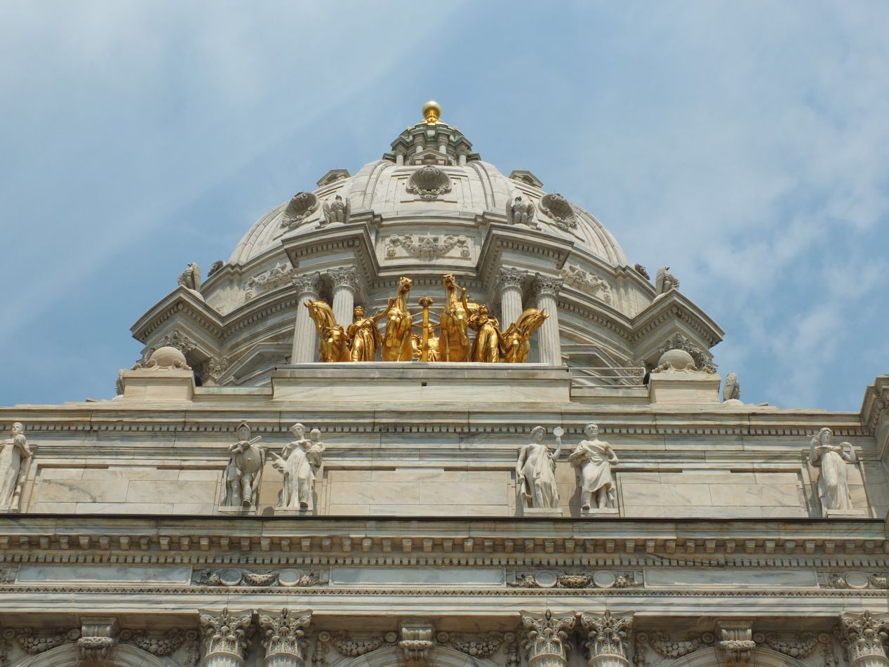


Despite being quite a bit smaller in size and population, it's St. Paul and not Minneapolis that holds the distinction of being the state capital. This means that it plays host to the Minnesota State Capitol building, which we were planning to tour next. The state capital was inspired by the design of St. Peter's Cathedral in Rome and the US Capitol building in Washington DC, featuring an unsupported marble dome in the center. Like most of the federal buildings in the nation's capital, the Minnesota legislative building also takes a lot of inspiration from the classical architecture of ancient Greece and Rome, with lots of pillars and marble statuary. It was completed in 1905 at the tail end of the Victorian period and reflects some of the attitudes of the era, with grand paintings celebrating civilization, commerce, and Christianity. The basement had some unusual designs painted on the ceiling with accompanying German text, a sign of the immigrant heritage from northern Europe that characterized Minnesota's history. Once we were ushered inside and our tour began, we were able to view the legislative chambers themselves:

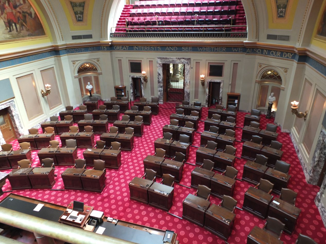


The top two pictures came from the Minnesota Senate while the bottom two came from the Minnesota House of Representatives. This is one state where the legislative makeup matches the same setup used at the American federal level. One quirk unique to Minnesota politics are the districts; there are exactly twice as many House districts as compared to Senate districts, with each one divided in two. For example, Senate district 19 has two House districts, 19A and 19B. Elections for the House are held every two years, while elections for the Senate are (mostly) held every four years, with an exception for an additional election following the publication of the Census every ten years when redistricting takes place. These are pretty big legislative bodies for state representation, especially in the Senate which is larger than any other state upper house with 67 members. Both of the legislative chambers imitated the ones in the US Capitol building, with the Senate being smaller and more intimate and the House a larger and open setting. I always enjoy visiting these legislative bodies in city after city, since they always have their little differences that help reveal a bit more about the people of that locality.


We were able to see this large church from the outside of the state capital building, and decided to head over to check it out. This was the Cathedral of St. Paul, dedicated to the patron saint from which the city takes its name. This is one of the largest churches in the United States, with a dome that stretches 75 feet across and 185 feet in height. The architectural style of the cathedral is Neoclassical, and the specific inspiration for St. Paul's Cathedral was Sacre-Coeur in Paris. This cathedral was built at the same time as the state capital, which makes sense given their similar overall styles, and completed in 1906. The church sits on top of a hill overlooking the western side of the city, and can be easily seen from almost anywhere else in St. Paul.

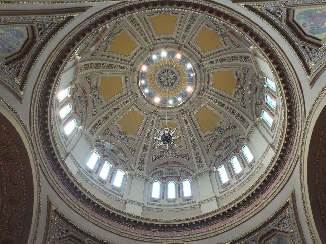


The interior was spacious and mostly deserted, with only a few other people inside. The ceiling with very high overhead, especially near the dome, and it produced the same kind of feeling that Gothic cathedrals often give off, the sense of almost being outside due to the height of the building. That dome was the main architectural feature of the cathedral, with a restrained sunburst design at the center and windows on all sids to let in outside light. Compared to some of the overdecorated monstrosities that I had visited in Europe, this place was quiet and subdued. My favorite feature was the stained glass rose windows; there were several of these along the outside walls with colorful displays of religious figures. The contrast between the light blues and dark purples was aesthetically pleasing in the rose window picture above. More humorously, there was also a Lego model of the cathedral tucked away in one of the side corridors, a 5 foot tall creation that involved the use of 70,000 Lego pieces. It supposedly took 150 hours to plan and build the model - time well spent.

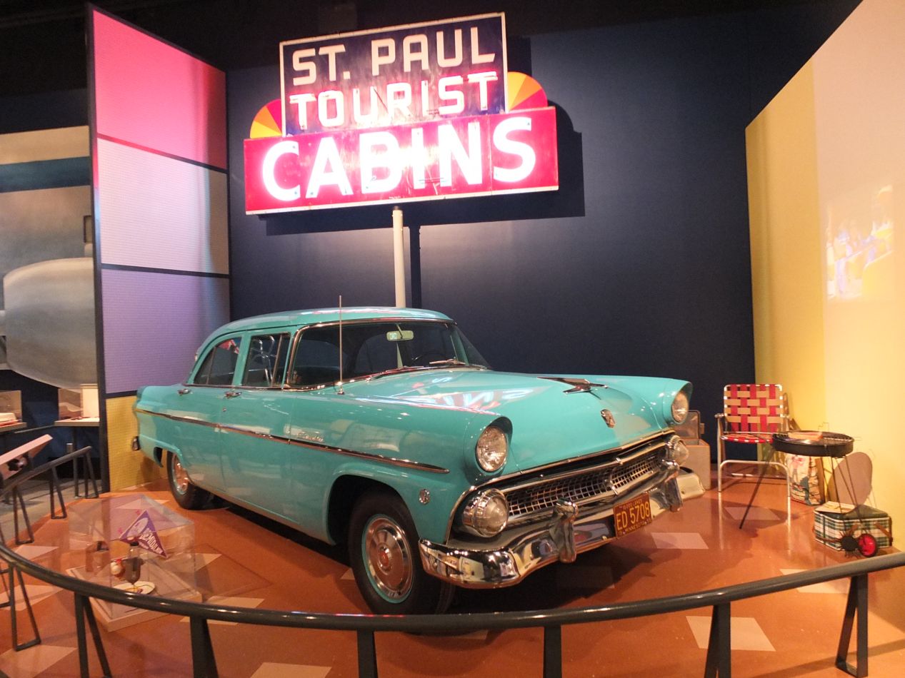


Within walking distance of both the state capital and the cathedral was this building, the Minnesota History Center. This was a museum and library that serves as the headquarters of the Minnesota Historical Society, with the museum holding most of the interest for non-researchers. This current building dates to 1993 and contains the more than one million artifacts in the possession of the historical society. The museum was quite good in its own right, with about half a dozen exhibits on different aspects of the state's history. There was a display about the "Greatest Generation" in Minnesota, the World War II generation and what life was like for them in its aftermath during the 1950s and 1960s. My parents particularly liked that one since it contained so many things they recognized from their childhood. There was a permanent exhibit dedicated to the state's history, and then a temporary exhibit about toys of the 1950s, 1960s, and 1970s. That one was a lot of fun to poke through, seeing all the action figures and dolls and board games that had been popular during these years. The museum even had old TV sets from the period hooked up and showing old broadcasts to help set the mood. This was a great place to spend a few hours.


Before leaving St. Paul, we headed down to the waterfront to get a view of the central business district. St. Paul is located about ten miles away downriver from Minneapolis, and the suburbs from the two have sprawled out far enough that they have essentially become a single urban area. For sports fans, the Twins, Vikings, and Timberwolves all play in Minneapolis while the Wild play in St. Paul. The University of Minnesota is also located in Minneapolis, and that was where we were heading next. There was another park that ran along the south bank of the river in St. Paul, and these pictures were taken looking north across the river towards the center of the city. This area was known as Harriet Island, although the land has been filled in and it's no longer an island anymore. There were several different steamboats here offering dinner cruises and sightseeing along the river, which we thought about doing before eventually declining. This was another place that was quiet in the late afternoon, a place to exercise and get away from the noise in the downtown.

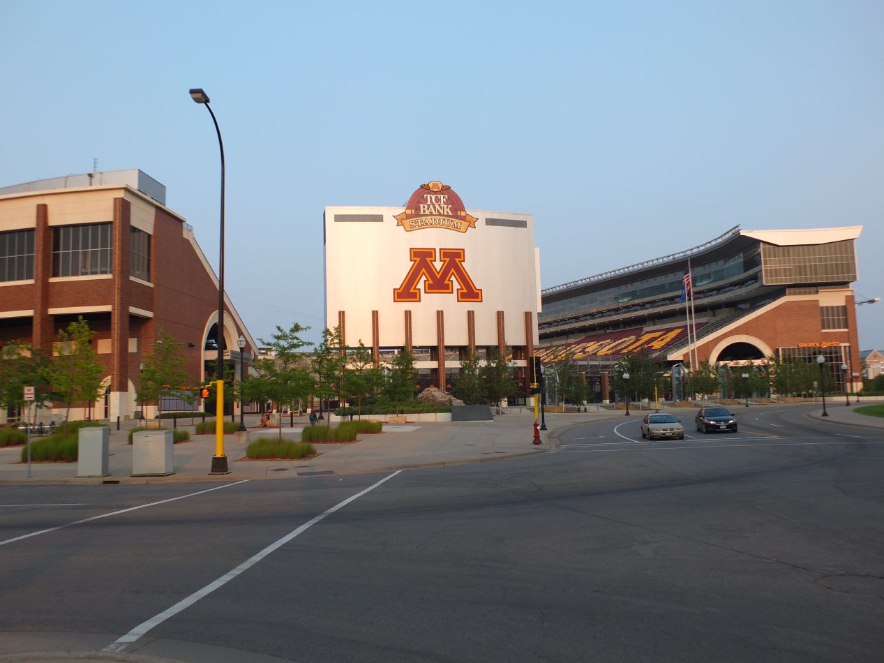


Our last stop for the day was at the University of Minnesota campus, which sits on the eastern side of Minneapolis. This was one of the schools where I applied to do my graduate work, and I might have gone here if they hadn't rejected my application. Oh well, their loss. The university has an attractive campus that runs along another part of the Mississippi River (as you've probably noticed, almost everything in the Twin Cities is close to the river). The northern edge of the campus hosts all of the sports facilities, most notably TCF Bank Stadium where the football team plays and Williams Arena that hosts basketball and ice hockey. Minnesota hasn't exactly been a juggernaut in football in recent years (or in recent decades) but they've had some very good basketball and especially hockey teams. I'm still not sure how to feel about these schools now that they are the supposed rivals of my University of Maryland. I don't think I'll ever be used to Maryland being in the Big Ten.
Elsewhere, the university had some beautiful architecture, especially the one building that looked like a castle. That's the armory and hosts the university ROTC from the limited information I've been able to dig up online. Like most other universities, Minnesota had a central open quad with a library at one end and the student union at the other end. There's a system of trolleys that run from the campus to both Minneapolis and St. Paul that make getting around to both of them easy. The only downside was the fact that part of the city near the campus seemed a bit sketchy, and it wouldn't be a good idea to wander around off campus at night in some areas. Overall though, this looked like a great place to go to school for anyone who doesn't mind the frigid winters.


After three days in the Twin Cities, we departed the next morning for Duluth and Lake Superior. En route to the next city, we stopped to do some hiking at Jay Cooke State Park. This is an area a little bit to the southwest of Duluth that runs along the banks of the St. Louis River. The highlight of the park is the area where the river runs through a rocky gorge, kicking up choppy white froth and providing impressive views of the natural beauty. A swinging bride crosses the river just downstream of the rapids, and the park's headquarters and departure point for its hiking trails are located nearby. The bridge pictured above was a recent construction; the historic bridge was destroyed by heavy flooding in 2013, and this replacement bridge had only been completed a few months before our arrival. The water came roaring through this area and made quite the spectacle as it plummeted over the rocks.


There were a trio of kayakers negotiating their way through the rapids when we were crossing the bridge, and we stopped to watch how they did. Their path over the larger falls went smoothly, only for one of the kayakers to wipe out when traversing a much smaller drop a little bit further down the river. The poor fellow had to use a rope to bail out of the situation since he couldn't get his kayak righted again in the swirling waters. Don't worry, he was OK once he was able to get over to the shore. We walked for a bit on the far side of the bridge and then returned back to continue the drive north. It was nice to stretch our legs and take in some of this scenery on such a lovely day.

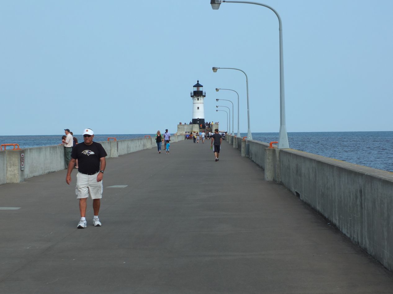


We arrived in Duluth in the afternoon and headed to the small downtown along the lake to investigate the Canal Park district. Duluth is a small city located at the westernmost edge of Lake Superior. It's known for being an industrial town based around maritime shipping; from this spot, ships can travel through all of the Great Lakes and through the Saint Lawrence to reach the Atlantic Ocean. Duluth also has the reputation for being one of the coldest non-Alaskan cities in the country, with the average low temperature in January around 0 degrees Fahrenheit (-18 degrees Celsius). Even here in mid-summer the temperatures were chilly in the evenings and had us breaking out light jackets. These pictures were taken at the entrance to the city's harbor, near the lighthouse at the end of the north pier. Duluth remains an active shipping port to this day, and this fully automated lighthouse still lights up at night to help guide ships into safe waters. The lake can sometimes produce terrible storms that destroy all visibility, and the waters are littered with the wrecks of ships that sank over the years. The bridge in the distance was the city's most famous landmark, the Aerial Lift Bridge, which we would be heading over to view a little bit later.

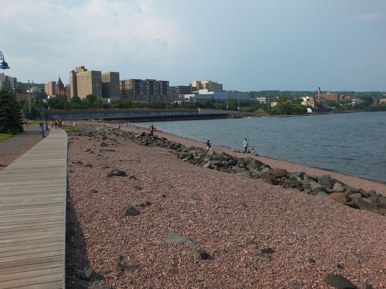


These pictures were from the walking trail that runs along the lakefront in the Canal Park district. Like many other cities Duluth has been experiencing an urban revival, and some of the lakefront property that used to hold decaying industrial structures has been redeveloped with apartments and trendy restaurants. In other places, the historic buildings have been preserved and repurposed to host new businesses. For example, this old Zenith Machine Company brick building had been turned into a wood-fired grill restaurant, which had full chickens roasting over an open fire in the seating area and served absolutely delicious food. I would definitely recommend them to anyone who might be passing through Duluth. A cool wind was blowing off the lake as we walked back towards the historic bridge, and it was almost cold outside as the sun began to set.

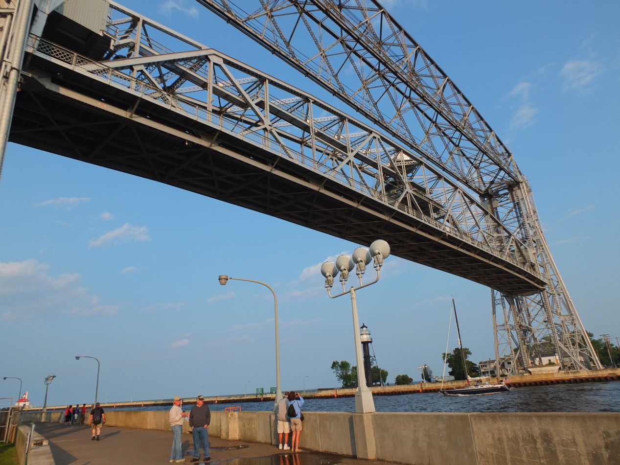


This is the aforementioned Aerial Life Bridge, the landmark symbol of the city. It stretches across the entry to the harbor where the St. Louis River connects with Lake Superior, and it's one of the few remaining vertical lift bridges still in operation today. The bridge was first built in 1905 at which time it actually transported passengers across to the other side on a little gondola as a transporter bridge. The current vertical design dates from a bit later in the 1930s. The Aerial Lift Bridge starts out in the "down" position as its default, which allows cars to drive over to the small island on the other side. When ships need to pass into or out of the harbor, the bridge operators shut down the car traffic and raise the bridge up vertically into the air, climbing 135 feet in about one minute of time. This is really neat to watch in operation, and we had the chance to see one large ship passing underneath the bridge while we were waiting. The bridge is in constant operation and raises about 20 times per day on average, which makes it easy to catch a ship passing through. There are shipping schedules in a small museum next to the bridge that make it trivial to see when the next one will be heading past and plan accordingly. In any case, the Aerial Lift Bridge is the most famous attraction in Duluth and almost impossible to miss for anyone visiting.


We had the next few days to spend exploring the area known as the North Shore, the coastline of Lake Superior that ran north from Duluth up to the Canadian border. This is a huge and sparsely populated area, with a single main road paralleling the lake that runs for 150 miles until hitting the border. Our first stop as we drove up the coastline was at Gooseberry Falls State Park. This is a small park based around a central waterfall, with the typical campsites and hiking trails spreading out from a main parking lot. The falls were quite popular on this sunny day and there were lots of families walking around on the surrounding rocks. Several of the hardier souls were swimming in the water itself, which had come running down from the hills further inland and was quite chilly. From this spot, we walked for about 15 minutes over to the lakefront portion of the park:


Lake Superior was calm and tranquil on this particular day, almost as smooth as a sheet of glass. The rugged shoreline revealed that this was not always the case, however, with craggy and weathered rocks running down to the water's edge. Hardy trees perched atop the rocks, clinging to them for shelter against the storms that must blow through this region. There was also a substantial amount of driftwood nearby, which the park staff had cleared from the little beach and dragged off to the side to make it more appealing for visitors. The shoreline of Lake Superior was quite pretty, and following this initial stop at a state park, we were about to see much more of it.

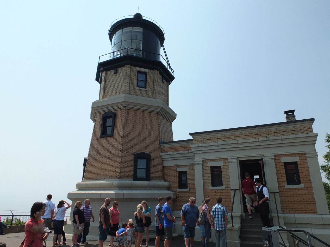


Split Rock Lighthouse State Park was located only a few miles further to the north and yielded similar scenery, with the added addition of a historic lighthouse. This particular lighthouse dates back to 1910 and has the distinction of being one of the most-photographed lighthouses in the nation. The rocks on this little promotory were responsible for several terrible shipwrecks in the early 20th century, which led local shipping companies to petition the federal government for the construction of a lighthouse. The structure was extremely isolated when it was fist built, with no roads at all along the North Shore and the lighthouse reachable only through a steam-powered derrick that hoisted people and supplies up to the top of the cliff. Once roads were finally built through this region, the lighthouse became very popular with tourists and therefore stayed in operation for a long time. It's been officially retired now but still operates on an automated basis. On our trip here, there was a line to go inside the lighthouse and we waited until we had the chance to enter. A spiral staircase rose about 20 feet until we reached a chamber with a huge glass lens overhead. The lighthouse itself wasn't anything special as far as lighthouses go; it's the picturesque location that makes this a tourist destination.

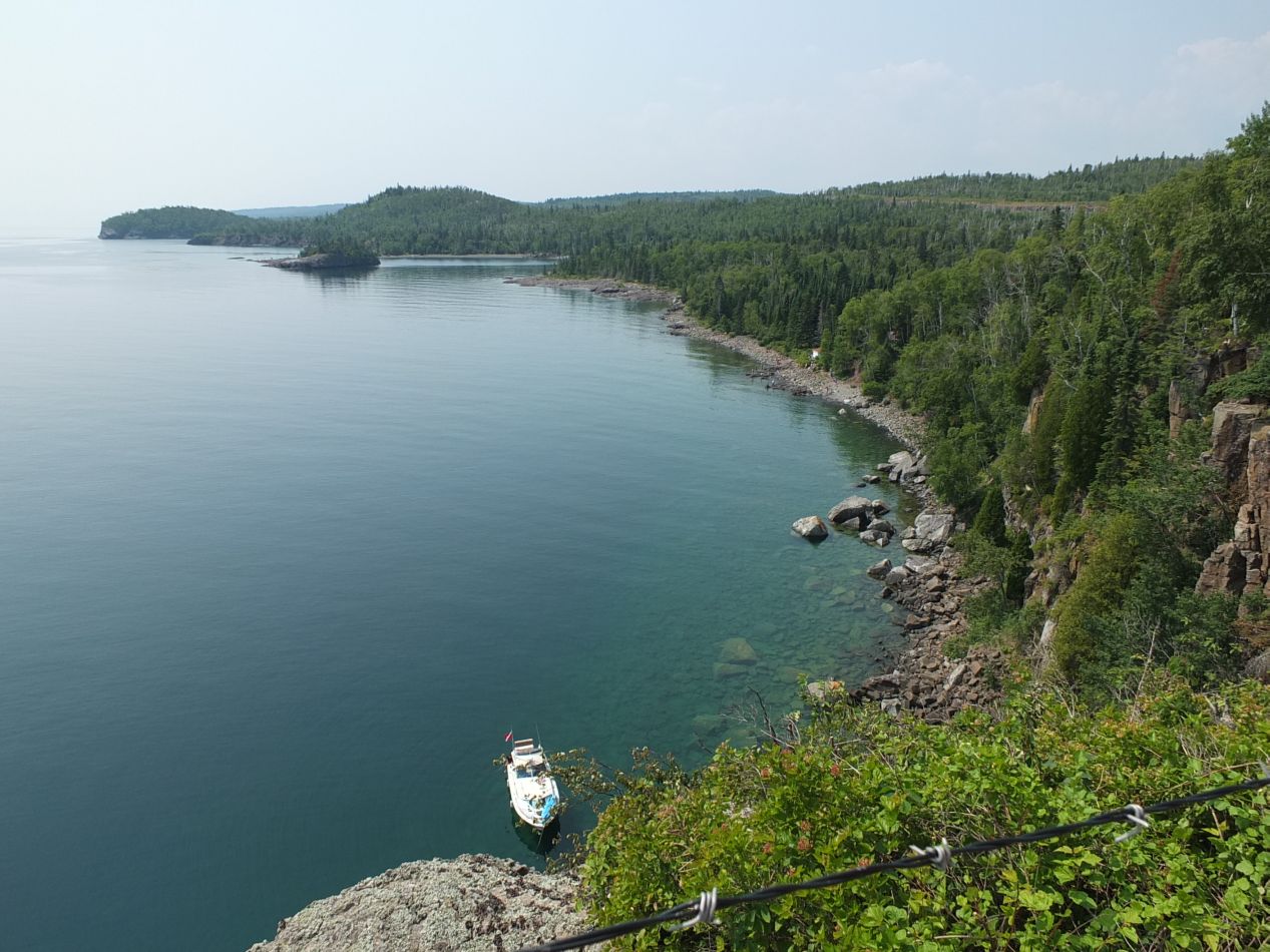


A wooden staircase descends from the top of the cliff where the lighthouse stands to a beach down below on the lake shore. This vantage point provides amazing pictures of the lighthouse up on its rocky hilltop, standing there jutting out into the surrounding waters. For that matter, the pictures of the surrounding landscape from the top of the cliff were incredible in their own right. The mixture of the short evergreen trees together with the weathered rocks on which they sat perfectly complemented the blue of the sky and the lake. The waters in the lake ran through dozens of different shades depending on the light at that moment, ranging from a turquoise that verged on the edge of green to a deep, dark blue. And it was clear as well, with the rocky floor of the lake easily visible from the top of the cliff. I tested the water by wading into it, and the water was very cold indeed for summer. This is one of those places that almost seemed designed to end up on postcards and photographs.

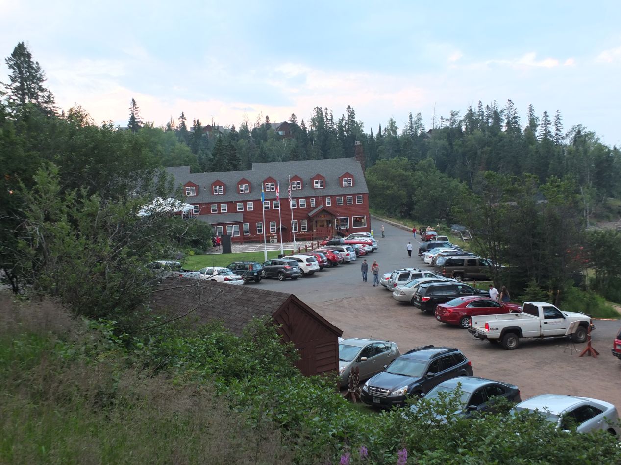


We were staying for the next few nights at a small resort known as Lutsen about two thirds of the way up the North Shore. This place had offered a bunch of online deals to attract visitors, and my family was able to score a surprisingly inexpensive price to stay at the facilities. Lutsen Resort dates back to the late 19th century, when a family of Swedish immigrants decided to turn their land on the shores of Lake Superior into a spa destination for wealthy travelers. The main lodge here dates all the way back to 1885, built almost entirely out of wood and rennovated to include modern amenities. This place offered a number of different activities to guests: swimming, fishing, kayaking, shuffleboard, spa treatments, and even a disc golf course that we tried out and enjoyed playing. This place had my seal of approval from the name alone: "Lutsen" is an Anglicization of the Battle of Lützen won by Gustavus Adolphus of Sweden in 1632. A place that commemorated a battlefiend from the Thirty Years War was right in my wheelhouse.

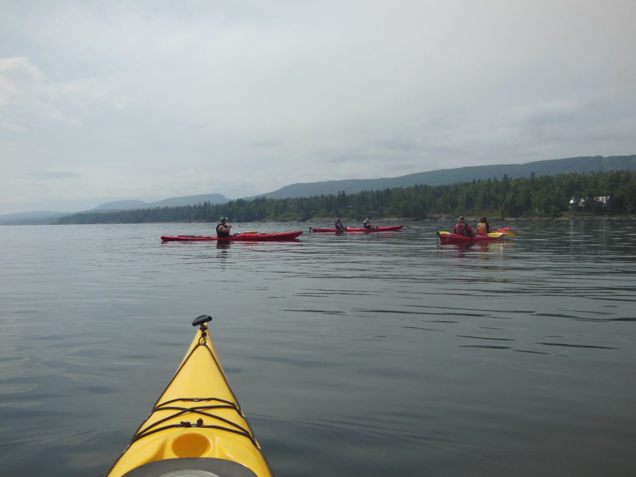


We went kayaking on the second day of our stay at Lutsen. This was part of a small group of about a dozen guests, with an instructor to lead and most of the participants doubled up in pairs. There was an odd number of guests and I was the lucky one who ended up with my own kayak. Believe it or not, this was the first time that I had ever been out on a kayak and I enjoyed the experience immensely. The lake was calm and still again underneath a cloudy sky that kept the sun from getting in our eyes. We paddled about a mile up the coast from the resort, stopping to see some private houses that hugged the shoreline and a few natural caves in the rocks. There was also a bald eagle up in a tree that one of the other kayakers spotted. That's me in the last picture looking tired after being out on the water for close to two hours. This was a ton of fun, and I would love to purchase a kayak if I ever lived in a position where I'd be able to use it regularly.

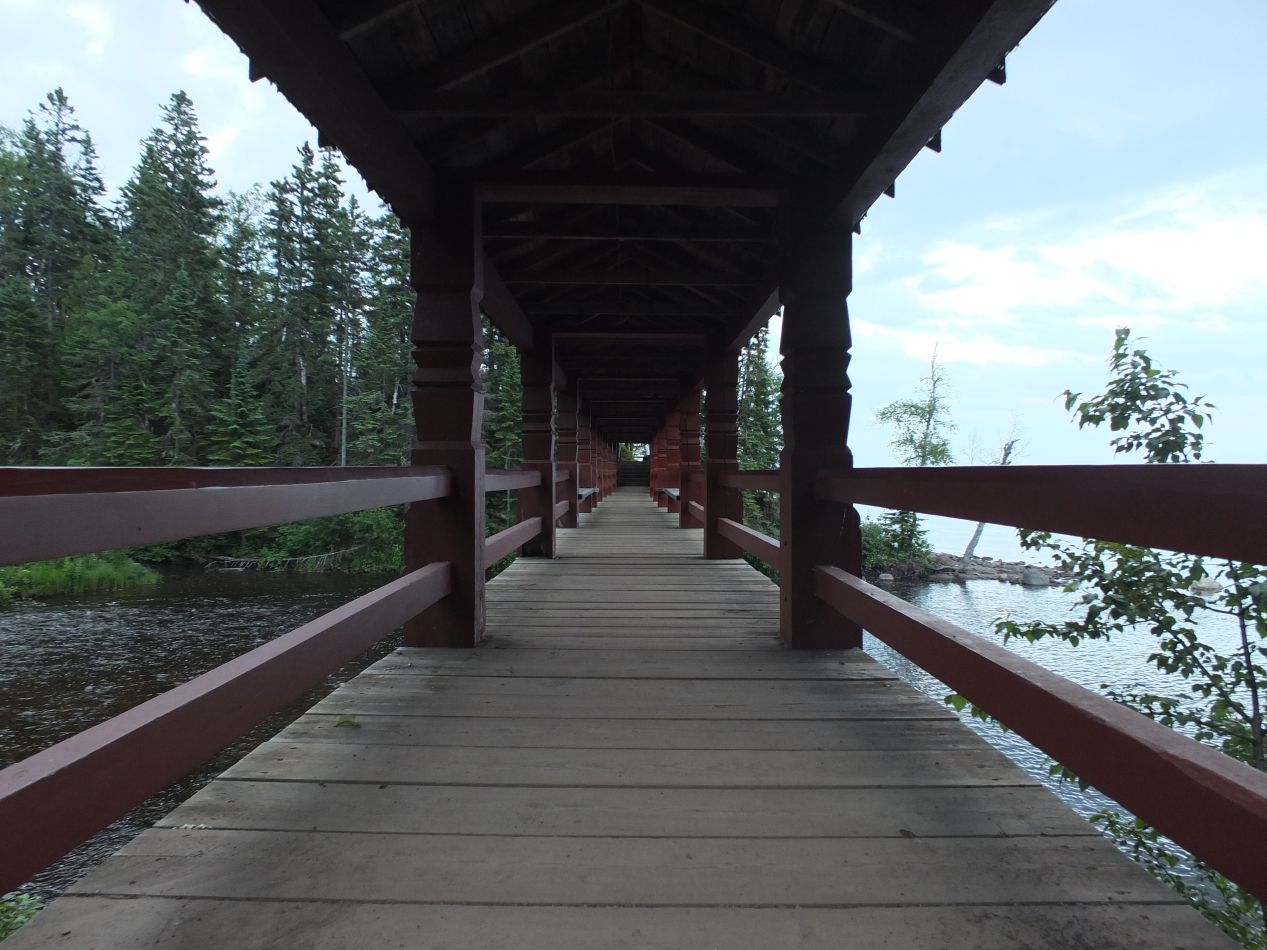


The resort at Lutsen also contained a series of walking trails that twisted through the surrounding woods. I had the chance to stroll through a few of those trails in the evenings, crossing a wooden bridge that spanned a small river just before it emptied into Lake Superior. The air in the forest was thick with the smell of evergreen trees, and after walking for five minutes it felt as though I was lost deep in the wilderness. In the dusky aftermath of a setting sun, it felt like a magical place transported far away from reality.

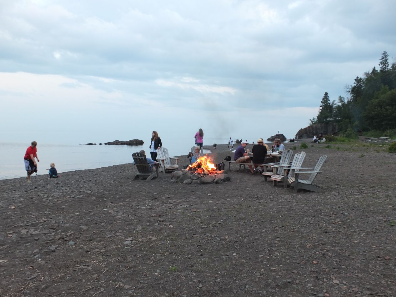


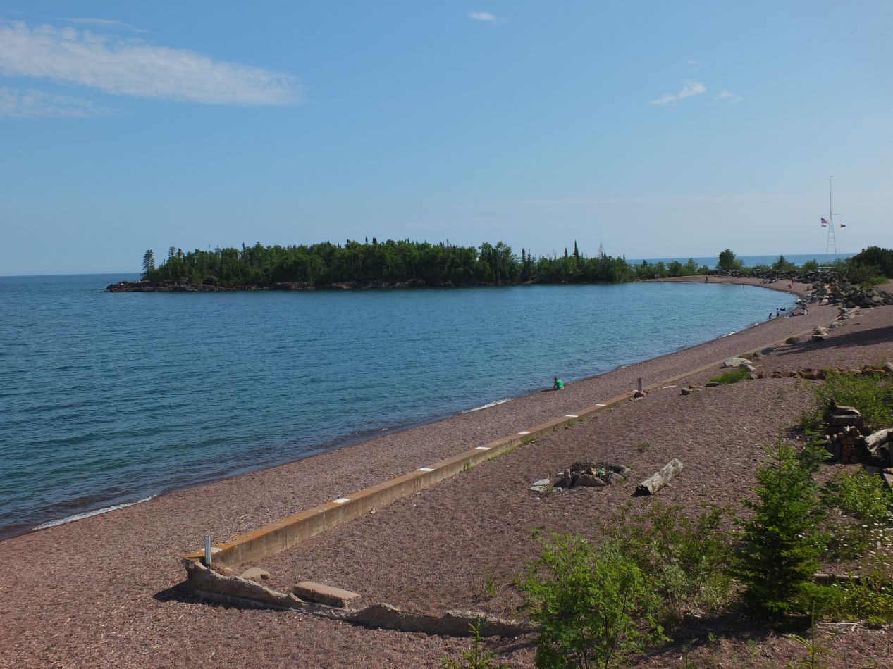
The resort had a small beach that ran along the lake's shore, and every night it filled up with families who had come outside to watch the evening roll in. There were several fires in their careful pits, and always one or two groups cooking food on a grill for their dinner. Children laughed and played in the sand on the beach, with hardly anyone else brave enough to go swimming in the water. I could have spent hours here reading a book and unwinding. With the onset of night, the wind began to pick up and small waves appeared for the first time on the surface of the water. The view off to the east was an undulating surface of dark blue as far as the eye could see. Between the kayaking and the evening walks along the lake, I really enjoyed the chance to stay at Lutsen. On the unlikely chance that anyone reading this is thinking about heading to the North Shore of Minnesota, I would definitely recommend this particular resort.

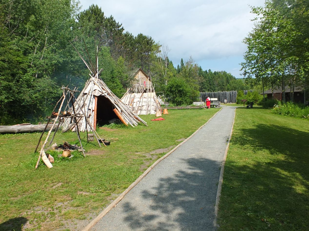


While staying in Lutsen, one of the places that we visited was Grand Portage National Monument. This is located up at the northern end of the North Shore only a short distance from the Canadian border. The name "grand portage" refers to the portaging, or carrying, of canoes across land from one body of water to another. This particular spot was the last and longest place where canoes had to be portaged from the vast network of inland lakes before reaching Lake Superior and the eventual passage to the other Great Lakes. These canoes were the only way to travel across the landscape in preindustrial times, and they were essential to the lives of the Native Americans of the region and the French fur trappers that arrived to trade with them in the 18th century. While it might seem strange today, the Great Lakes region and the upper Mississippi were dominated by the French in the early colonial period, and a ton of the place names in this region come from French roots, like the nearby "Isle Royale" national park. Grand Portage National Monument is dedicated to telling the history of this region through the combination of a small museum and the reconstruction of buildings from the late 18th century.


Since this is an American national monument, the organizers have decided to reconstruct a British trading outpost operated by the North West Company. That's not historically inaccurate by any means, but the British only operated in this region from about 1770-1800 before moving further north into what became Canada, and the French interactions with the Native Americans lasted much longer and were more culturally significant. The fur trade itself collapsed in the early 19th century as prices fell from oversaturation of the markets in Europe, and this had a devastating impact on the local Chippewa population who had become dependent on the trade. In other words, while the historical moment depicted here was real enough, it lasted for a relatively brief period in time, one generation at most. If I'm being a stickler about this point, blame it on someone who taught history courses for a decade. It's way too easy to think of depictions of the past as static and unchanging when life was often anything but.
I did get a kick out of that sign by the lake: "Danger - Extremely Cold Water." That's not something that you'll see in most places! 

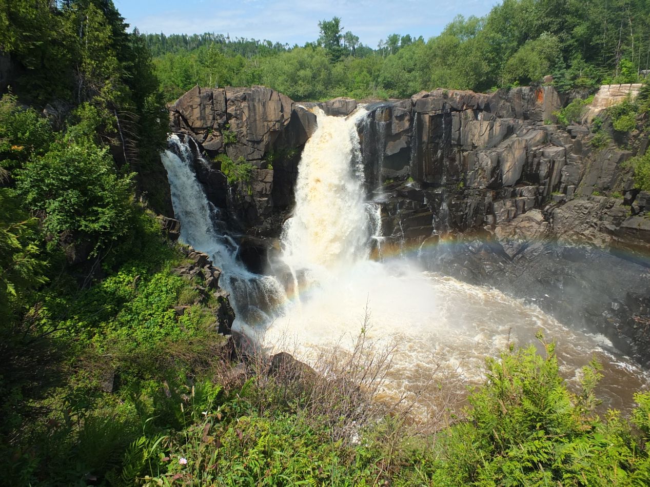


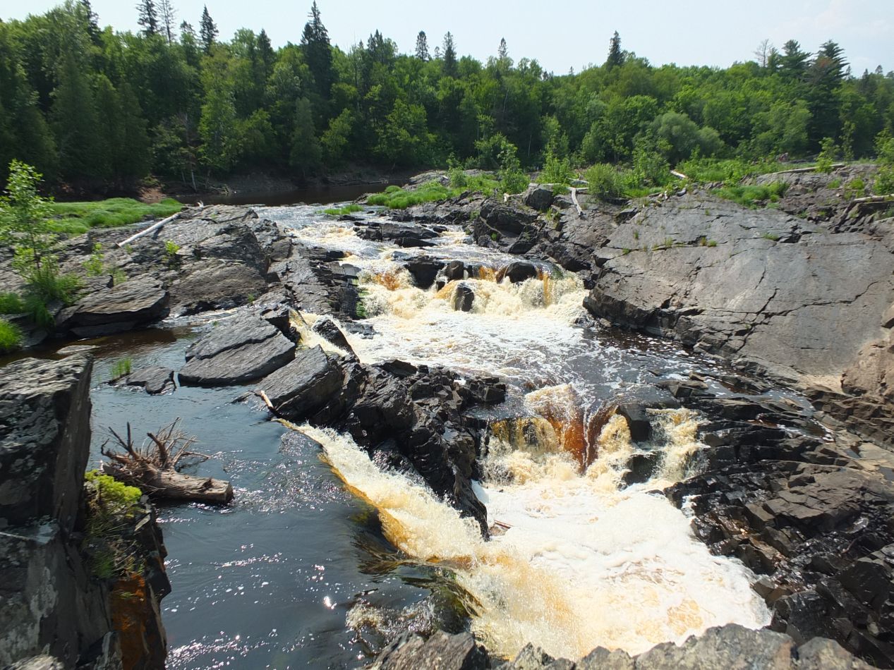
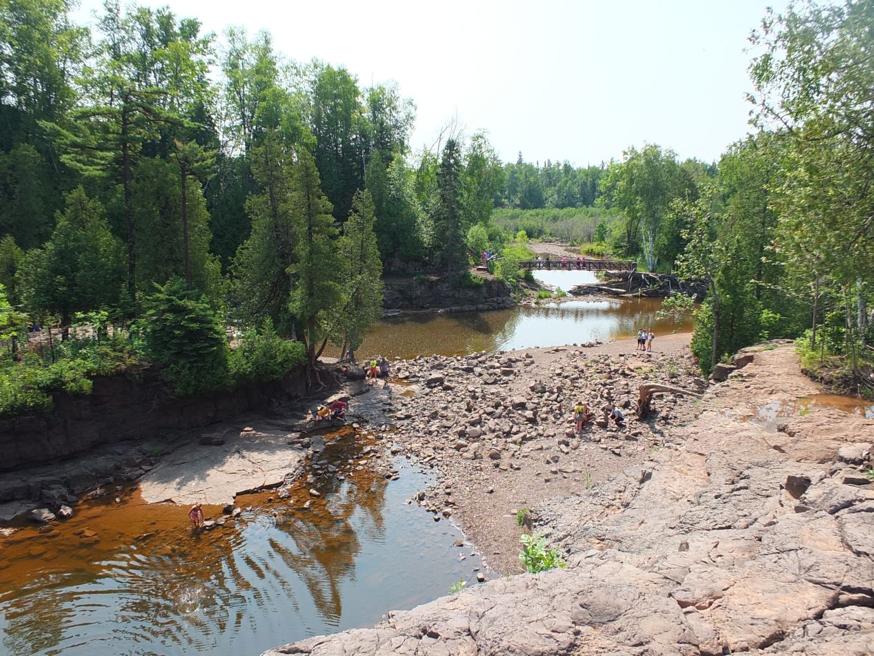
We traveled from Grand Portage National Monument over to the nearby Grand Portage State Park. This was even closer to the Canadian border, and passed so close that we could have thrown a stone over to the Canadian provincial park on the opposite side. There was a hiking trail here that led through the woods and eventually crossed over onto a raised wooden platform. That elevated path led to a viewing platform for the featured attraction of the park, the big waterfall known as Pigeon Falls. Raging torrents of water poured through a narrow channel and sent water turned yellow with foam down to crash on the rocks below. It was extremely loud near the falls and difficult to hear anyone more than a step away. For anyone wondering why the whole Grand Portage thing existed in the first place, this was the reason: the need to portage canoes around several large waterfalls like this one. Since it wasn't possible to take a canoe over the falls, they had to be carried over land to reach the nearby lake shore. Incidently, this body of water is known as the Pigeon River, and it forms the border between Canada and the United States here in the northeastern most extreme tip of Minnesota. I wasn't exaggerating when I said that you could throw a rock over to the other side; in some places, I could have jumped across the border.


We made another stop for a few hours at the little town of Grand Marais, a bit further to the south along the North Shore. This was another place with a history of heavy French influence, with the name meaning "Great Marsh" and providing a hint as to what the place looked like three centuries ago. Grand Marais today is a charming small town on the lake's edge, with boutique stores displaying artisan wares and a good number of cafes. We had lunch here at one of the small restaurants and then did some shopping in the stores. This was where I purchased my one souvenir of the trip, a model of a canoe decorated in the artistic style of the local Chippewas. It felt like the best symbol to capture the unique historic circumstances of this corner of the world.

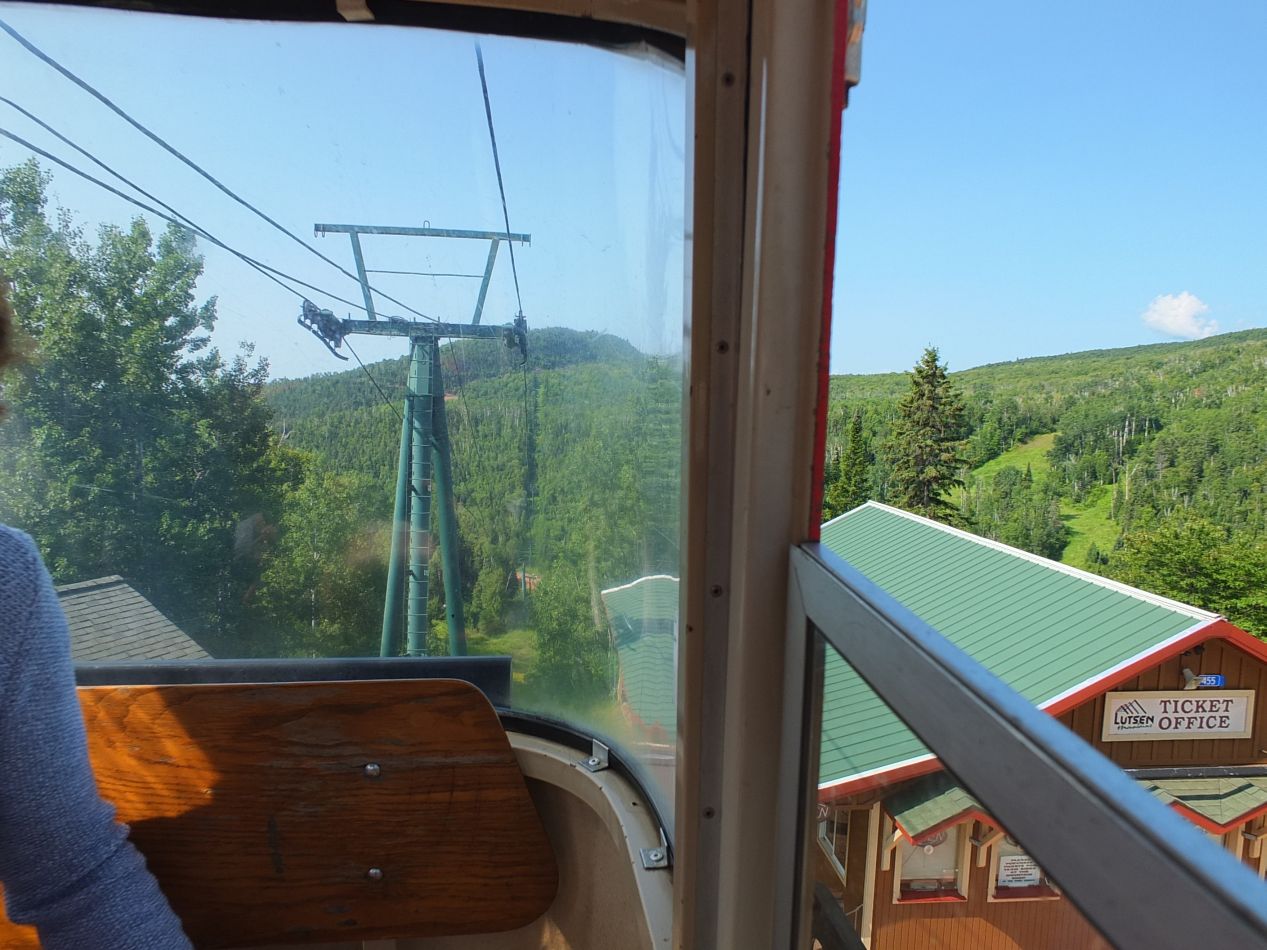


The last place that we stopped along the North Shore was the skiing area in the town of Lutsen. There were a series of Scandinavian-style chalets here that had been built in decades past, emphasizing again the Swedish influence on this little village. Most of the action at Lutsen takes place in the winter and it was pretty deserted for the most part. However, one of the gondolas was open and carrying visitors up to the top of a hill to provide views of the lake below, and this seemed like it would be a fun activity to try. The gondola had glass windows on all sides and showcased views of, well, lots and lots of trees. It was very green even if there wasn't too much else around. The most interesting part of the trip was the flight over a bubbling mountain stream. As with everything else in this region, the water looked clear and very cold.

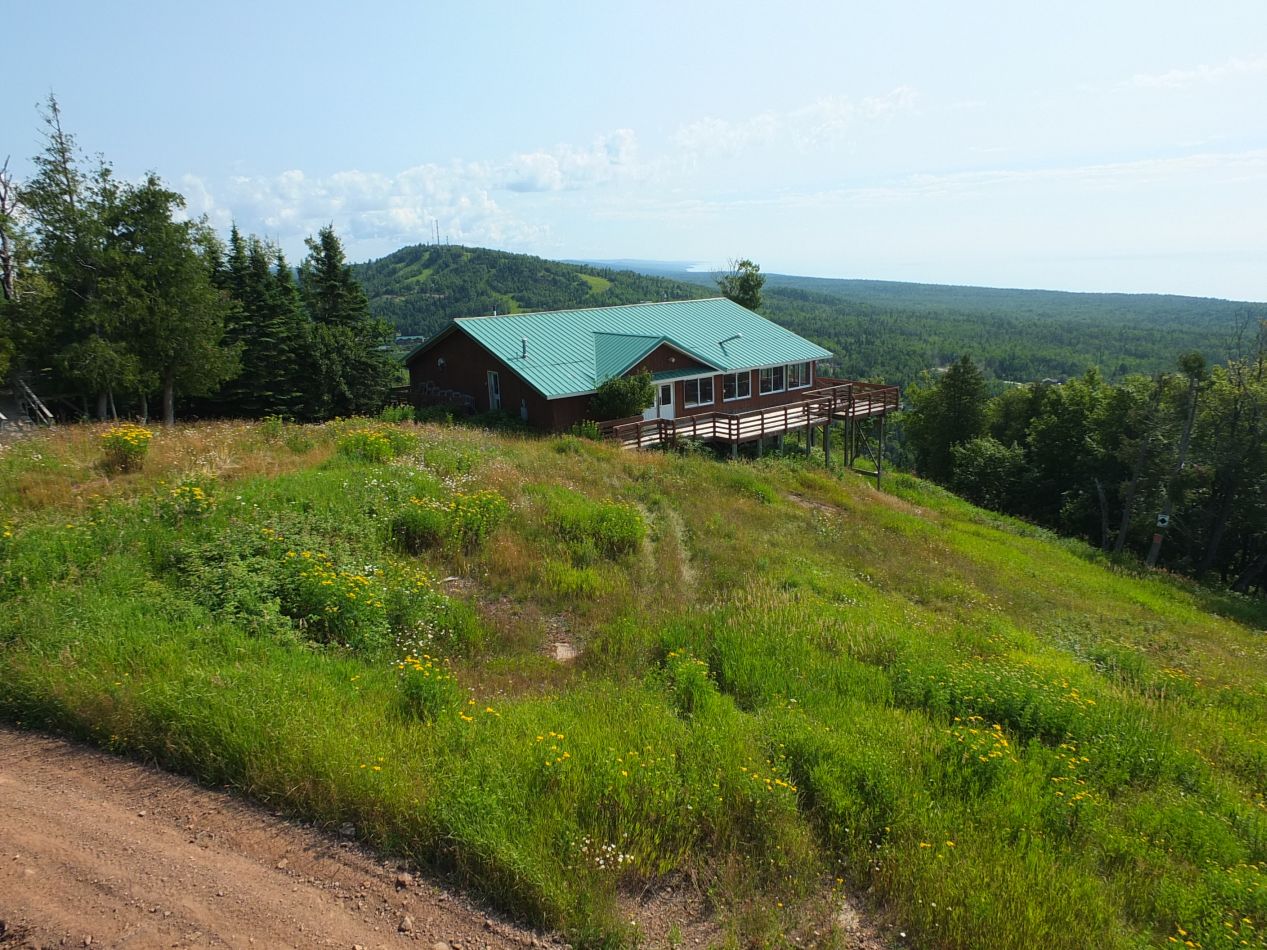


We had good views from the top looking down at Lake Superior below. Unfortunately it was a little bit hazy and these pictures didn't take as well as I would have liked. This was my first trip with the camera that I would later take to Alaska and Europe, and I was still tinkering with the settings. The lake could very well have been an ocean from this vantage point, stretching endlessly off to the east with no end in sight. Lake Superior is the largest lake in the world after all, at least unless the list includes the Caspian Sea like the one on Wikipedia does. The interior of the chalet at the top was equally interesting, a cozy place that sells food and hot beverages during the skiing season. This must be a nice place to come inside when it's bitterly cold in the winter. I also liked the classic skiing posters adorning one of the walls, if not the $86 price tag that they were asking for them.
That was the last place that we visited on the North Shore. We had to drive back to Minneapolis for the flight back home, and there was one more attraction remaining to see in the big city:

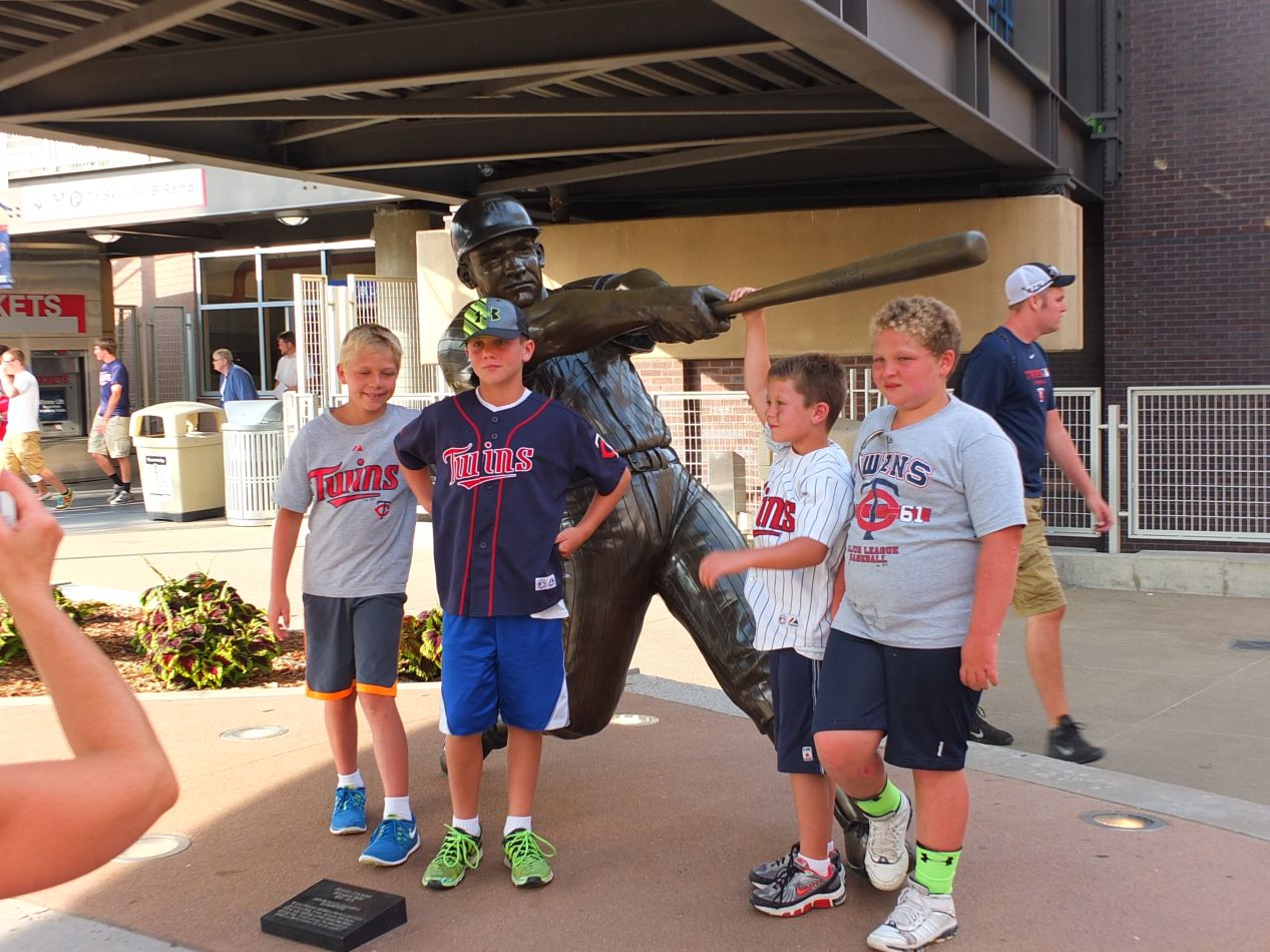


Minnesota Twins baseball!  My family is made up of huge sports fans, and if there's a baseball game taking place in a city that we're visiting, we'll definitely make sure to get tickets to at least one game. The Twins play in Target Field in downtown Minneapolis, a beautiful facility that had only been open for a few years when we visited. The Twins had hosted the 2014 Major League Baseball All-Star Game only three weeks before these pictures were taken and there were still signs touting the All-Star Game all over the place. It was a good thing that the Twins had been picked to host the game since they completely stunk in 2014, finishing with 70 wins against 92 losses and ending up in last place in their division. Their poor record ensured that we would have no trouble getting tickets as we picked out seats in the upper deck on the third base side. If there was one other thing the Twins weren't lacking, it was merchandise - the store with Twins gear was enormous!

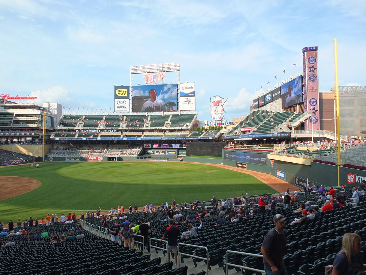


This is the view of the field itself from the first base side. The most famous part of this stadium is a version of the old fashioned team logo, the twin cities of Minneapolis and St. Paul shaking hands underneath a big baseball. That sign lights up whenever a player from the home team hits a homerun as fireworks go off in the background. The stadium was also built to provide great views of the Minneapolis skyline beyond right field, where there's also a big electronic version of the Target dog that lights up at night. (That's the Target Center where the Minnesota Timberwolves play; Target has its headquarters in Minneapolis and appears to own much of the city.) This is one of the things that I can never understand about Nationals Park in Washington DC: given the chance to build the stadium with views of the Capitol building and the Washington Monument, the stadium architects designed it so that the field faces the opposite direction where none of them are visible. The Twins didn't make the same mistake with their hometown, and the result is a more interesting place to watch a ballgame.

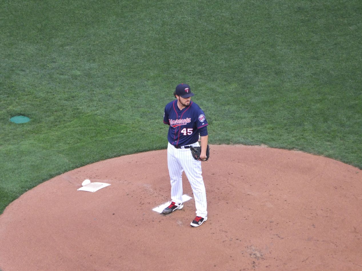


The first picture above was the view from our seats. Not bad at all from cheap seats in the upper deck. This game took place on Tuesday, August 5th 2014 and I'll link the box score on Baseball Reference for the curious. It was an interleague matchup between the Twins and the Padres, two bad teams that had nothing of interest to play for this season. Phil Hughes was pitching for the Twins and he had been one of the few bright spots for their rotation that year. This game turned into a defensive struggle that stayed scoreless into the 5th inning. Hughes kept putting Padres batters on base and then finding ways to work out of trouble without giving up any runs. The Padres would end up going 0 for 4 with runners in scoring position and stranding 11 men on base, with their only run coming on a solo homerun. It wasn't exactly a clutch performance. As for the Twins, they did absolutely nothing all game aside from the bottom of the 6th inning, when Kennys Vargas homered with two men on:

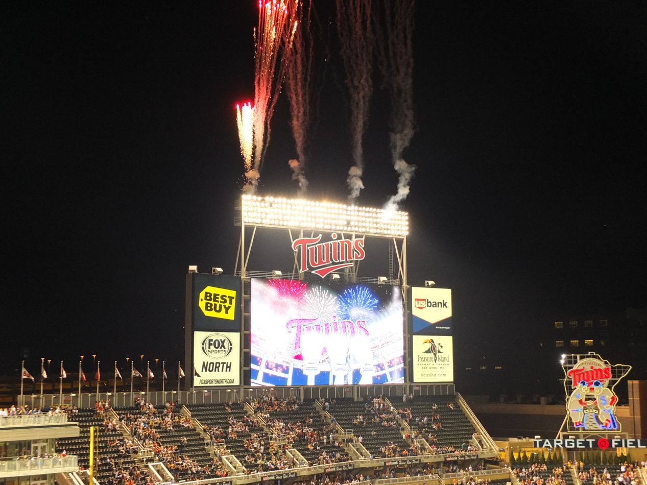


We were therefore lucky enough to see the fireworks go off and the Twins sign light up, much to the delight of the local fans. That was all of the scoring that the Twins managed to do, and it was enough to hold on for the 3-1 victory. The Twins were outhit 12 to 5 and still managed to take this game due to the offensive ineptitude of the Padres. It wasn't a night to remember from the perspective of the baseball talent on display, but we thoroughly enjoyed seeing the stadium and getting to watch the game.
From Minneapolis, we flew back home to Baltimore the next day. Although this wasn't the longest or most dramatic trip that I had ever taken, it was a pleasure to see a part of the country that I had never visited before, especially the dramatic scenery along the North Shore of Lake Superior. The countryside in that region was still mostly untamed, and the rocky promontories that overlooked the lake were among the most beautiful scenery that I've had the chance to visit. Minnesota is a wonderful state with a lot of diverse attractions, and hopefully I've managed to highlight some of the range of different places on display for tourists. As always, thanks for reading and happy traveling.


