
This was where my trip through eastern Canada really started to get exciting. I was about to take a ferry from the northern edge of Nova Scotia over to Newfoundland, the easternmost island province that has always stood a bit separate from the rest of the nation. Newfoundland wasn't even part of Canada until 1949, having remained as a separate British colony up until that point. I had wanted to visit the island known by locals as "The Rock" for a long time and this was my first opportunity to do so. I would be spending two days exploring the spectacular scenery of Gros Morne National Park, located on the western edge of the island, and that is the focus of this particular page of this travel blog. If you were ever curious about what the fjords of Norway would look like if they were transposed to the Canadian Atlantic coast, this is the place to see.


Before anything else I had to reach Newfoundland. Since it's obviously an island locale, there are only a handful of ways to reach this destination. The most common modern form of transportation is to fly to Newfoundland, and most visitors will take a plane to St. John's on the eastern edge of the island and then drive around from there. The only other way to travel to Newfoundland is via a ship of some kind, and I would be taking the ferry service from the town of North Sidney on Cape Breton Island. In order to make the early morning ferry, I had to line up with my car at 3:00 AM so that everyone would have time to load and be settled for the 6:00 AM departure. That's where these images were captured above, with our cars lined up and ready to proceed into the belly of the huge ferry craft. It was just visible in the distance as a hazy blur at the edge of the water.


Eventually the ferry began loading the cars one at a time, and I drove in follow-the-leader fashion up a long ramp into one of the lower decks of the big ship. There's a picture above of what the interior holding area looked like where the cars were stored. There were nine total decks on the ship, with the passenger area located on the seventh floor. It featured several television screens, places to sit and relax, and a cafeteria serving hot meals. While I wouldn't describe any of this as luxurious, it was comfortable enough. This was also a place with accessible wi-fi for Internet use, and the Newfoundland ferry became another another entry on the list of strange places from which I logged into a Civ4 Multiplayer Pitboss game.
The eighth floor was where most of the commercial trucking vehicles were stored, probably because they were too large to fit in the interior hold of the ship, and then the ninth floor was an outdoor observation deck. I spent a good bit of time up there while the ship was preparing to cast off, looking back at the town of North Sidney and then staring off at the waters in the Gulf of Saint Lawrence as we began to move. The sun had just pulled above the horizon in the east under a mostly cloudy sky, and due to the early hour most of the other passengers were downstairs sleeping or watching TV. There were only a handful of other people around as the ship released the last line and began steaming out into open waters. This was my favorite part of traveling: the wind in my face, the waves of the sea gently rocking below, and my heart full of a sense of adventure. I was venturing off into strange new lands just like the ancient mariners of yore. Everyone should get the chance to share an experience like this.

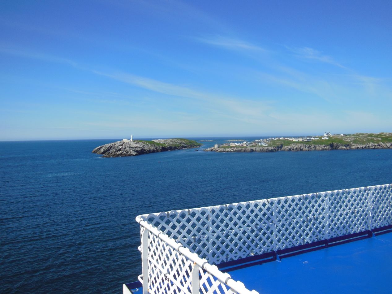


I stayed on the top deck for almost an hour until the last bit of Cape Breton slipped out of sight behind us. Afterwards, I went down to the passenger deck and slept for a few hours now that we were out of sight of land. By the time that I woke up again in midmorning the ferry ship was far out at sea, with clear blue waters extending in every direction. The day had cleared up and the sky was almost empty of clouds, with the azure firmament above matching the ocean waters below. It was a gentle passage over to Newfoundland, something that I was grateful to see since the waters in the Gulf of Saint Lawrence can be very choppy when it storms. The ferry eventually reached its terminal destination at Channel-Port aux Basques, a town located at the extreme southwest tip of Newfoundland. The ferry is the main reason why anyone ever travels to Channel-Port aux Basques, although it was a pretty enough location in its own right, with mostly white buildings perched at the edge of the land. It was immediately clear to me why Newfoundland is known as "The Rock" to its inhabitants, with the town sitting atop some very rocky ground. This is an area with a tough climate and the soil was too weak along the coast for any trees to grow. I still had a long way to travel this day, and I didn't stop to explore Channel-Port aux Basques, instead driving onwards towards Gros Morne.


The drive from Channel-Port aux Basques up to Gros Morne National Park took about four hours to complete, with the distance of 330 kilometers (about 200 miles) taking longer due to the lack of major highways. Gros Morne itself is a national park designated in 2005, the second-largest national park in Canada after the absurdly remote Torngat Mountains National Park in northern Labrador. Gros Morne gets is name from Gros Morne peak, a French phrase meaning "large mountain standing alone" and a place with an excellent hiking trail that I would be exploring during my stay. The park is known for its unique geology with a mixture of many different types of rocks, some of them dating all the way back to the Palaeozoic era, as well as its beautiful fjords. This is a remote part of Newfoundland and Gros Morne doesn't get too many visitors even during the summer tourist season. I never had to deal with any crowds during the time that I spent in the park.


These first pictures were taken at Norris Point, one of the small communities located within the boudaries of the park itself. Norris Point sits on a head of land that juts out into Bonne Bay, with a population of only 850 people according to one of the signs on display. I approached Norris Point on the road from the north and was treated to these beautiful views looking down at the small collection of buildings. There were long expanses of tough, short evergreen trees here blanketing the hills, and they made for a verdant green contrast against the blue of the sky and the waters. Down at the edge of Bonne Bay, I also spotted this bizarre formation of clouds out over the water. Although the sky above was completely clear, there was a thick white cloud sitting atop one of the hills and extending out over the small bay. I've never seen anything quite like this before or since, even though I'm sure that there's a natural explanation for it. Honestly, the whole thing looked like a spellcaster was trying to provide cover for an adventuring party to sneak through the area.  This thing could have come out of the special effects department on a movie set.


I was staying for two nights in Gros Morne at the town of Rocky Harbor, the largest community located within the park. I use the term "largest" loosely though, as Rocky Harbor couldn't have had more than a thousand or two inhabitants at maximum. A series of clouds had rolled in across the waters to the west as I entered the town, and by the time that I arrived, Rocky Harbor was shrouded in thick fog. I stopped at the local lighthouse atop the deliciously-named "Lobster Cove Head" but unfortunately couldn't see much of anything. One of those pictures above is supposed to be a panoramic shot of the town, and it mostly just shows a whole bunch of white fog. I stayed at the hostel pictured above, a small place that could accomodate 25 people but housed fewer than 5 people when I was there. My communal room simply became a private room since there was no one else staying in any of the other beds. I liked staying here due to a combination of the dirt cheap rooms ($15 per night in 2013 dollars was little more than a joke) and the lack of distractions. It was quiet and peaceful here both nights that I stayed.


I woke up the next morning, and wow, what a difference a day made! The skies were completely cloudless and there was nothing but sunshine everwhere. I returned back to the lighthouse on Lobster Cove Head and deliberately took the identical pictures from the day before, this time without any fog to block the views. This revealed the small lighthouse itself for the first time, as well as the town of Rocky Harbor. The buildings were laid out along the coast in a semicircle following the contours of the land, and there was another small town (Woody Point) visible across the water on the other side of the bay. This was the early morning and it was quiet and still outside, with hardly anyone else up and moving about outside. Perfect weather for sightseeing.

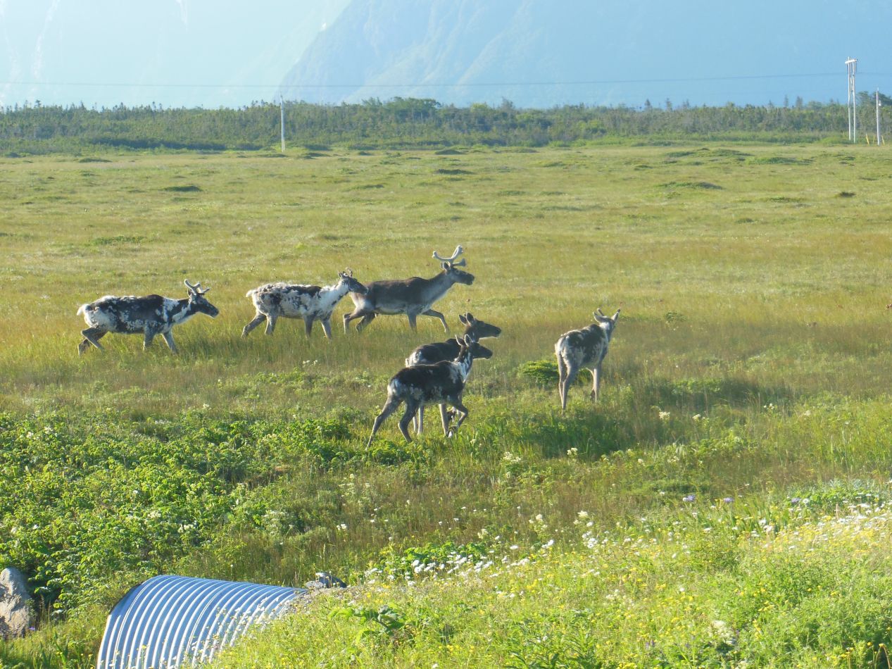


I love driving on an open road like this one, with absolutely no cars in view and the horizon stretching off endlessly into the distance. I was heading north through Gros Morne National Park along the western coast of Newfoundland and the scenery was nothing less than beautiful. You may have noticed the tire marks on the road above, which unfortunately came from my car. I had slammed on the brakes when I spotted some caribou passing along the side of the road, which I did manage to capture in the picture above. This herd was roaming about enjoying the summer weather, and there presence was a sign that I was definitely visiting a cold weather climate. When you see wild caribou grazing outside, better make sure to have a warm coat handy. Further up ahead, I came across this lovely river that ran down underneath the road and emptied into the sea. It was so pretty that I had to get out of the car and take a few pictures. I don't think that I could design a natural river that looked too much nicer than this.
At this point, the actual route of my trip took me up to the ferry at Saint Barbe and over to Labrador for a day. That part of the trip is discussed on the next page of this travel section. On my way back south again the following day, I returned to Gros Morne and had the chance to see more of the scenery, which is what I'll be covering next. (This is the reason why the weather and the time of day are suddenly different in the following pictures, not some kind of crazy midday shift.)


One of the major reasons why I had wanted to come to Gros Morne was to hike up the mountain that forms the park's namesake. The trail was listed at 16 kilometers (10 miles) total distance for the roundtrip journey, with a suggested timetable of 6-8 hours for the full hike. The trail gained 800 meters of vertical elevation in traveling up the mountain and I knew it wouldn't be for the faint of heart. Still, I had done more serious hikes than this in the Rocky Mountains, and I thought that I wouldn't have too much trouble. In fact, I had scheduled a boat tour on Western Brook Pond for the same day at 3:00 PM, and in order to make sure that I was finished in time to catch that tour, I decided to start my hike at 5:00 AM. This ensured that I would have the mountain entirely to myself, with virtually no one else on the trail. As long as I could keep myself out of any trouble along the way, this would be perfect conditions for a long hike.


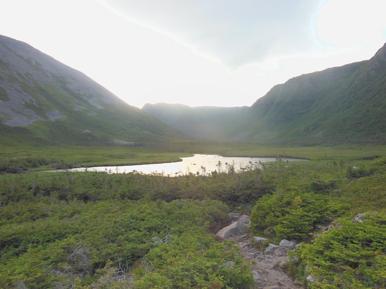
The initial few miles of the trail passed through dense forests, sloping only gradually upwards. This was a pleasant morning hike and not terribly difficult, although it was uphill enough that it wasn't a casual stroll either. I couldn't see too far ahead most of the time, and when I could see up ahead, it was to look at a different mountain than the one that I would eventually be climbing. The early part of the trail pointed towards a peak known as Crow Cliff before finally turning towards Gros Morne itself. After about 90 minutes of walking, I reached the base of Gros Morne proper:


That was the peak that I would be climbing, the rounded and weathered shape rising up above the little lake off to my left. The trail didn't wind up to the top, instead heading straight up the narrow vertical shaft on the side of the mountain. This little section of the trail is known as "The Gully", and it's extremely steep on the ascent, one of the most difficult trails that I've ever tried to climb. There were not one but two signs at the base of the peak warning visitors of the danger of heading upwards. This seemed a little bit silly to me standing there at the bottom. Fall over a cliff and result in death? That seemed excessive. I would be careful but I was still heading up the trail regardless. (Spoiler alert: I did make it back to the bottom of the mountain.)


The climb was difficult. I was headed up a rock face with lots and lots of small stones underfoot. I spent a lot of this time scrambling upwards on all fours, using my hands as much as my feet to pull myselfs upwards. The closest analogy that I can come up with is scaling a staircase that lasted for hundreds and hundreds of steps, only there was no sure footing here and every footfall had to be placed with great care. I didn't take too many pictures during the ascent because I was focusing on staying upright and not falling down. When I did pause to look back eventually, I saw that the pond at the foot of the mountain had shunk down to miniature size. Now that I was this high up, I could see out over the trees and the hills to the water in the distance. I was also getting a fresh appreciation for those warnings down at the base of the climb. In poor weather or the kind of dense fog that I had experienced in Rocky Harbor earlier, this really would be a dangerous place and not to be underestimated.


Eventually I reached the top and the path flattened out again. I had reached the summit of Gros Morne and the land up here was a bit of a plateau, gently rolling terrain with rocks strewn about everywhere. The park staff had been forced to set up small flags to mark out the path, which otherwise would have been indistinguishable against the sea of little stones. There were no trees up here at this elevation, only tough grasses and a few very hardy scrub brushes. I saw one small bird off to the side of the path, with brown and white feathers that perfectly blended into the rocks scattered about. That was a textbook example of an animal adapting to blend into its natural environment. Up at the summit itself, there was a small sign sitting in a field of more rocks. It really looked like a giant had smashed a huge boulder into thousands and thousands of little pieces up here at some point in the distance past. This is one of the few places where I took a selfie on this trip, capturing the moment when I made it up to the top. There wasn't a soul here, and for the moment I had the pinnacle of Gros Morne entirely to myself.

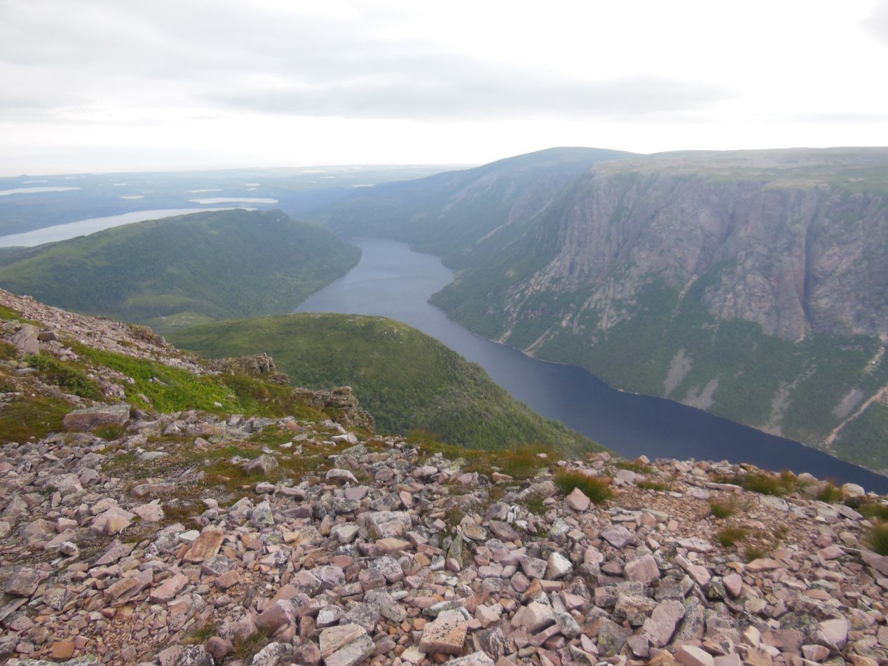


The most famous view from the top of Gros Morne was a little bit further along the trail. At the northern end of the mountain, the land falls away sharply to provide a stunning view looking down at Ten Mile Pond. There was no railing or guard system in place at all near the edge, and suddenly I understood the warnings at the bottom of the trail. If it were foggy or raining heavily, someone absolutely could walk over the cliff's edge and plummet to their death. The wind was swirling about on the top of the peak and I was hesitant to get too close. I managed to get one great picture looking down, and then kept heading along the trail, expecting it to circle back to the cliff's edge again later on. Well, it never did come back and I was left with just the one picture, which was a failure on my part. Whoops, my mistake. For some reason I had thought there were more chances to capture that viewpoint. Anyway, the rest of the descent was a lot less nerve-wracking, with some long wooden staircases to ease the trip down the back side of the mountain. The walk on the way back bypassed several lakes and followed the path of a little river. When I reached the treeline and proceeded back towards my car, I started passing other hikers for the first time, who were shocked to see someone coming back down the mountain at 9:00 AM. They understandably couldn't believe that I was already finished. In fact, the whole hike only took about five hours to complete and I was done before 11:00 AM, leaving me with several hours to kill before my boat tour that afternoon. While that was a bit of a waste of time, better to be running early than running late.


A few hours later, I drove over to Western Brook Pond and prepared for the boat tour of the fjord. I suppose I should clarify that this isn't actually a fjord because it doesn't connect out into the Gulf of Saint Lawrence just two miles to the west. Instead Western Brook Pond is an enclosed ecosystem unto itself, with unique species of land and water creatures living around and inside its chilly waters. Just reaching the dock where the boat tour launched was a minor journey unto itself, with a walk of nearly an hour required to reach the pond. The path from the parking lot out to the boat dock took me across a series of wooden platforms laid out atop the marshy ground. It was very windy, and the stubby grasses were swaying to and fro in the breezes coming in off the ocean. This was one of those rare occasions where it was possible to see the movement of the air, with rippling waves passing through the grass and whitecaps stirred up along the pond's surface. It was a relaxing scenic walk, and a lot easier than the one that I had done earlier the same day.

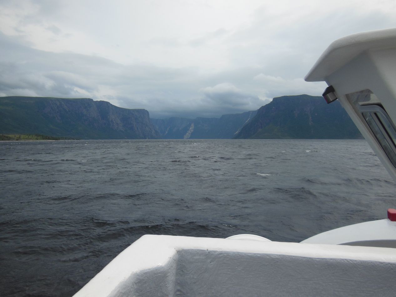


The tour boats plying Western Brook Pond were small affairs, carrying about 50 tourists at most on each trip. This was the most expensive part of my stay at Gros Morne, and the only attraction where I'd needed to make a reservation ahead of time. When we boarded the boat and headed out into the waters of the pond, it immediately became apparent that this trip would be a lot rougher than the one on the huge ferry ship that had brought me to Newfoundland. The wind was whipping up some decent waves on the surface of the water and the small boat was bobbing up and down constantly, carried from crest to trough between each wave. This was a lot of fun and practically worth the cost of the boat ticket all on its own. Up ahead were the deep sides of the canyon, carved out by glaciers in Canada's recent geological past. It was very easy to imagine that I was in Norway here, touring one of the fjords (as I would actually do several years later).


The boat eventually took my tour group to the eastern head of Western Brook Pond, where it narrowed and finally came to a close at a river mouth. The tour guide said that sometimes backpackers heading into the deep wilderness of the park will asked to be dropped off here, and then spend several days making their way back to the entrance. We spotted several waterfalls along the way, including one far up at the top of the rocks that sent water plunging hundreds of feet down towards the pond. Even better, we spotted a pair of moose off in the distance, with what looked to be a moose cow and her calf. The tour lasted for about two hours in all and was a fantastic experience, highly recommended for anyone else who might find themselves in western Newfoundland. It takes a lot of effort to reach Gros Morne, but the park itself is nothing less than spectacular.
Western Brook Pond was the last place that I visited in Gros Morne. In my actual itinerary, I headed further east the next day and experienced more of Newfoundland. But for the purposes of this travel blog, we'll back up a day here and cover my visit to the Labrador Coast. This was the most remote destination on my whole trip, and it was a chance to visit a part of Canada that few people would ever see. Outside of the famous breed of dogs, Labrador is a place far off the beaten path.


